
Revised: Tribeca Resources Pre-Drilling Field Program Reveals Potential District-Scale Porphyry Epithermal Cluster at Jiguata Project
7 JULY, 2026 – TheNewswire - VANCOUVER, BC - Tribeca Resources Corporation (TSXV: TRBC) (OTCQB: TRRCF) (“Tribeca Resources”, the “Company”) is pleased to report technical updates from field programs completed at its Jiguata high sulphidation - porphyry copper exploration project in northern Chile (“Jiguata”, or the “Jiguata Project”), including geological mapping, soil and rock chip sampling, spectral and geophysical programs; together with a drilling update from its La Higuera Project (“La Higuera”, or the “La Higuera Project”).
The recently completed pre-drilling field program at the Jiguata Project has generated geological, geochemical, spectral and geophysical datasets that the Company interprets as consistent with a district-scale porphyry and high sulphidation epithermal cluster. These are preliminary interpretations, with no assurance that they will be confirmed by drilling.
Highlights:
Jiguata
-
Geological mapping and spectral interpretation have outlined large alteration footprints at the four distinct alteration centres, interpreted as potentially reflecting multiple intrusive centres across the project area.
-
Spectral results show alteration patterns interpreted as consistent with porphyry/epithermal environments, with mineral assemblages indicating epithermal advanced argillic alteration and porphyry-related phyllic alteration.
-
Soil and rock geochemical results present coincident Mo-W-Bi ± Cu anomalism, interpreted as potential porphyry-style pathfinder geochemistry, together with As-Sb-Te ± Ag-Au anomalism typical of lithocap and high sulphidation epithermal environments.
-
Ground magnetic 3D modelling has defined discrete magnetic lows proximal to stronger magnetic highs, interpreted as related to alteration and intrusive bodies, respectively.
-
3D inversion of the magnetotelluric (MT) geophysical survey has identified a number of resistivity signatures that the Company interprets as consistent with porphyry and epithermal systems, with important coincidence with the historic IP data.
La Higuera
-
At the La Higuera project in the coastal IOCG Belt, drilling has been completed at the Chirsposo Sur target and assay results are pending.
Tribeca Resources CEO, Dr. Paul Gow commented:
“The recently completed field programs have delivered a substantial amount of new technical information across the Jiguata Project and have materially improved our understanding of the property. The geological, geochemical and geophysical results from this extensive period of boots-on-the-ground work continue to support Jiguata as a compelling exploration opportunity. The pre-drilling programs have provided a strong platform for refining our integrated model and advancing Jiguata toward our maiden drill program.”
“The majority of the new data received to date covers the large La Soberana and Cetro Dorado alteration systems, which are shaping up as the initial drill targets. The multi-kilometre extent of the geochemical and geophysical anomalies in this area is highly encouraging, and we look forward to the challenge of siting the initial drill holes.“
Overview of the Jiguata Project
The Jiguata Project is a 10,000 hectare property located in the Tarapacá region in northern Chile. It is situated in the northern extension of the prolific Palaeocene and Eocene-Oligocene porphyry copper belts where it is overprinted by the younger Miocene Belt of magmatism that hosts recent large-scale high sulphidation epithermal gold and porphyry copper-gold discoveries further to the south, including Vendaval Cu-Au Porphyry (First Quantum) (“Vendaval”) and Salares Norte Au-Ag High Sulphidation Epithermal (Goldfields) (“Salares Norte”). References to nearby or regional deposits are provided for geological context only. The presence, size or grade of mineralization on other properties in the belt, including Vendaval and Salares Norte, is not necessarily indicative of mineralization on the Jiguata Project.
Tribeca holds the Jiguata Project under a five-year purchase option agreement (the “Jiguata Option”) to acquire 100% of the property. The terms of the Jiguata Option are outlined in previous news releases, including the Company’s news release dated June 19, 2025.
Geological mapping at the Jiguata Project
Historic geological mapping was focused in the central Jiguata area and undertaken in 2010-2012 by the project vendors. Tribeca has, this year, extended this mapping over much of the property area, with a focus on the exposed alteration systems where erosional windows exist within the overlying thin post-alteration andesitic volcanic unit.
On the basis of the geological mapping program, in particular the identified alteration assemblages and observed vein relationships, it is interpreted that the current exposed level at Jiguata represents the upper portion of a preserved porphyry-epithermal system. Results suggest the project is prospective for porphyry-style Cu-Mo-Au mineralization as well as high sulphidation epithermal Au-Cu-Ag mineralization associated with advanced argillic alteration, hydrothermal breccias and vuggy silica bodies. The key results from the geological mapping of the alteration centres (Figure 1) are discussed below:
Cetro Dorado
At Cetro Dorado, the easternmost alteration centre, mapping identified extensive zones of Type D quartz sulphide veinlets within advanced argillic alteration and hydrothermal jarositic breccias coincident with local stockwork vein networks interpreted as having affinity with Type B porphyry-style veining.
The combination of advanced argillic alteration, hydrothermal brecciation and porphyry-style vein textures at surface is considered by the Company to support Cetro Dorado as a key potential drill target.
La Soberana
La Soberana, the southernmost alteration centre, is characterized by multiple hydrothermal breccia bodies intermittently outcropping over an area approximately 1.8km in strike length spatially associated with extensive advanced argillic alteration.
In the southern part of La Soberana, fine banded quartz veinlets and breccia clasts containing grey quartz veinlets were observed and are interpreted as having affinity with “Type B” style porphyry veining. The observed Type-B veining may provide indications of a relatively shallow emplacement of prospective intrusive centres within the area.
The La Soberana alteration centre hosts the only historic drilling in the project area, with two shallow reverse circulation drill holes completed in 1993 to approximately 250m to 300m depth in the western portion of the system (Figure 1). The holes are considered to have been too shallow to intersect the remodelled geophysical targets as discussed below.
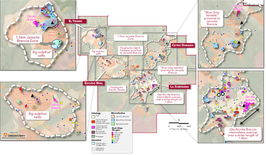
Click Image To View Full Size
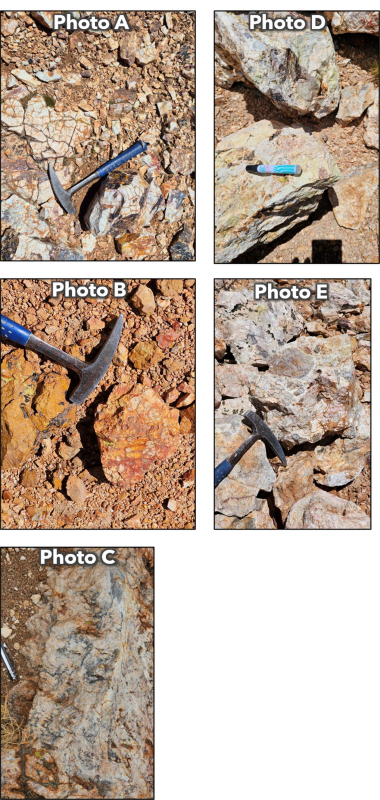
Figure 2. Representative photographs of selected rock types observed at Jiguata (locations referenced in Figure 1)
Photo A: Fine-grained tuff with jarosite stockwork.
Photo B: Jarosite ± quartz–alunite hydrothermal breccia.
Photo C: Blueish grey-black quartz veinlets (“Blue-Grey Veinlets”) in quartz-alunite ± kaolin (AA) hydrothermal breccia. The veinlets are texturally similar to “Type-B” veinlets (Blue veins) typically found in Cu-Mo porphyry systems.
Photo D: Chenevixite-Jarosite in alteration surfaces and fractures. Chenevixite is typically produced from the oxidation of enargite, potentially indicating the presence of hypogene copper sulphides in the area.
Photo E: Quartz-alunite ± kaolin hydrothermal breccia with “Blue Grey Veinlets” and grey quartz and jarosite veinlets, fillings and alteration surfaces.
El Trono
El Trono is located on a prominent topographic high and remains only partially evaluated due to more challenging access conditions. Mapping identified extensive advanced argillic alteration, hydrothermal breccias containing grey chalcedonic quartz fragments, pervasive jarosite alteration, traces of banded quartz veining, clay-rich alteration and hydrothermal infill of a rock flour matrix.
The strongly brecciated material identified in the field is consistent with the upper expression of a hydrothermal system with evidence of multiple phases of epithermal and potential porphyry overprinting. The combination of advanced argillic alteration, hydrothermal brecciation, multiple phases of porphyry and epithermal-style veining and alteration and residual silica development is interpreted by the Company as supporting further evaluation at El Trono.
Spectral data and interpreted alteration assemblages
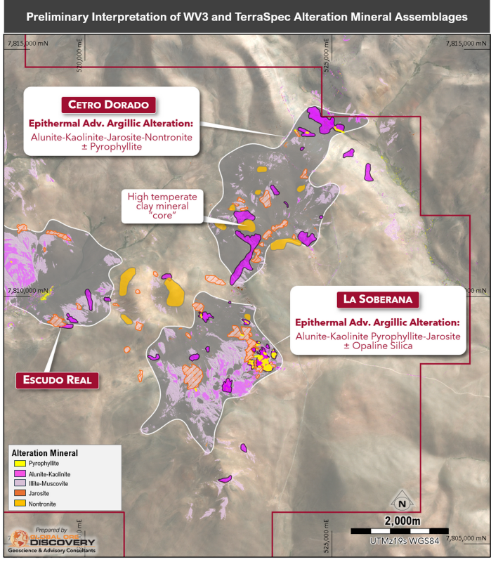
Spectral modelling of high-resolution WorldView-3 satellite imagery has been integrated with Terraspec spectral data from soil and rock chip samples across the project area. Interpretation of these datasets has enabled alteration mineral mapping against mineral assemblages commonly described for large-scale porphyry and epithermal systems, including those outlined by Halley et al. (2015). Supported by geological mapping, the combined WorldView-3, soil and rock chip spectral datasets have identified alteration minerals interpreted to represent typical porphyry-epithermal alteration patterns, including:
-
-
Large-scale kaolinite ± alunite ± jarosite, hematite and goethite alteration zones typical of advanced argillic environments;
-
Illite ± smectite ± jarosite assemblages in WorldView-3, soil and rock chip data, interpreted to represent a transition to phyllic alteration that may form a continuum with the observed illite-muscovite deeper in the system and in some cases are overprinted kaolinite-rich assemblages;
-
Opaline silica responses identified in the WorldView-3 datasets, commonly proximal to localised alunite and jarosite responses and consistent with vuggy silica development;
-
Mixed phyllic and advanced argillic alteration responses that appear to daylight through interpreted post-mineral cover, including transported material and areas of thin post-alteration andesite; and
-
White mica response in the WorldView-3 data, including sodium-rich paragonite zones associated with interpreted advanced argillic alteration. These paragonite-rich zones may provide vectors toward hydrothermal source areas.
-
The mapping of these key alteration patterns across the four alteration centres is documented in Table 1, with the spatial distribution over the La Soberana and Cetro Dorado centres shown in Figure 3.
Click Image To View Full Size
Figure 3. Spectral interpretation with simplified alteration assemblages. The interpretation is based upon both the spectral data from the detailed Worldview-3 satellite data and Terraspec data acquired from both rock and soil samples.
Table 1. Summary of alteration centres and classification derived from interpretation of spectral datasets derived from WV3, soil and rock chip datasets.
|
Alteration Centre |
Alteration Assemblage |
Iron Oxides & Jarosite |
Comments |
|
La Soberana |
Alunite - Kaolinite +/- silica jarosite |
Ferric Fe > Ferrous with abundant jarosite |
Porphyry related phyllic and argillic to advanced argillic overprint -localised paragonite +/- muscovite high temperature spatially associated with alunite – kaolinite – silica responses proximal to mapped hydrothermal breccias developed within a broader phyllic zone – possible porphyry alteration overprinted by epithermal style – developed proximal to confluence of interpreted NE and N trending faults. Alteration likely obscured by younger sequences in the east and south. |
|
Paragonite +/- Muscovite |
|||
|
Cetro Dorado |
Alunite - Kaolinite +/- silica jarosite |
Ferric Fe > Ferrous Fe with moderate jarosite |
Epithermal advanced argillic - zone trending towards the north with a separate jarosite+ phyllic alteration area developed towards the southwest of a broad propylitic alteration centre. Northern portion of the alteration centre presents as more epithermal style alteration with more phyllic +/- jarosite + silica in the south. The southwestern portion of the broader continuous propylitic alteration zone may hint at alteration obscured by cover to the east of the centre. |
|
Illite-Sericite +/- Jarosite |
|||
|
Escudo Real |
Muscovite – illite +/- jarosite |
Ferric Fe > Ferrous Fe |
Propylitic alteration with discrete phyllic zones - broad area of propylitic alteration with jarosite responses likely obscured by younger cover or erosional features – weaker phyllic response evident – possibly more distal to source or obscured by cover. ALOH trending k-rich where jarosite responses more dominant |
|
El Trono |
Alunite - Kaolinite +/- silica jarosite |
Ferrous Iron > Ferric Iron with moderate Jarosite |
Epithermal advanced argillic - locally intense alunite – kaolinite – silica responses developed within propylitic halo – locally muscovite dominant towards argillic response |
Geochemical Results
The field program included the collection of 672 soil samples and 149 rock chip samples across the Jiguata Project. To date, multielement results from 314 soil samples and all 149 rock chips, predominantly from the La Soberana and Cetro Dorado alteration centres, have been received and interpreted. The new multielement data was integrated with the historic 599 soil and 177 rock chip results and evaluated against the mapped lithology and the corresponding alteration centres.
Preliminary interpretation has outlined two principal geochemical associations as follows:
-
an As-Sb-Te ± Ag-Au geochemical association spatially associated with an alteration mineral assemblage characterized by kaolinite ± alunite ± jarosite, hematite and goethite. This signature is consistent with a high sulphidation epithermal environment and/or a porphyry-related lithocap; and
-
an anomalous Mo-W-Sn-Bi ± Cu geochemical association that is typically considered a porphyry-style magmatic hydrothermal association. This element suite may reflect a magmatic hydrothermal fluid component and provide a vector toward a concealed porphyry centre, intrusive cupola or related mineralized source.
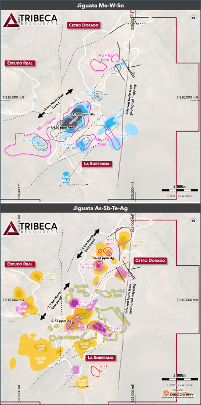
The distribution of these two geochemical associations in the La Soberana, Cetro Dorado and Escudo Real alteration centres is provided in Figure 4.
Click Image To View Full Size
Figure 4. Distribution of selected elements derived from geostatistical analysis and well-documented porphyry/epithermal geochemical indicators, from historical and recently analyzed soil geochemical data from the Escudo Real, Cetro Dorado and La Soberana areas. Highlighted geochemical values are derived from soil geochemical results.
La Soberana
Geochemical results from systematic soil sampling at La Soberana have delineated an approximately 2 km long by 1 km wide, coincident Mo–Sn–W anomaly spatially associated with interpreted northeast trending structures (Figure 4). At the same location, soil geochemical anomalies of As–Sb–Te ± Ag–Au extend over a similar strike length of approximately 2 km. The Mo–Sn–W association may reflect proximity to an intrusive or porphyry-related mineralizing centre, whereas the As–Sb–Te ± Ag–Au assemblage is characteristic of higher-level epithermal environments. Collectively, these results highlight the potential for a telescoped porphyry–epithermal mineral system at La Soberana, with northeast-trending structures interpreted to have been a possible control on hydrothermal fluid flow and the distribution of potentially associated mineralization.
Cetro Dorado
At Cetro Dorado, results define the strongest lithocap-style geochemical and alteration expression identified to date at the project, with elevated As-Sb-Te ± Ag-Au anomalism spatially associated with kaolinite-alunite-jarosite-hematite alteration. Mo-W-Bi ± Cu anomalism is present but less coherent than at La Soberana, potentially indicative of a more limited influence of the potential porphyry mineralizing source, or the development of a stronger overprint remobilizing any original porphyry geochemical signature.
Escudo Real
At Escudo Real, spectral and geochemical results indicate kaolinite ± alunite ± jarosite ± hematite/goethite alteration associated with elevated As-Sb-Te ± Ag-Au anomalism. Local copper anomalism provides indications of a potential contribution from a deeper hydrothermal mineralized system, although the broader Mo-W-Bi ± Cu porphyry-style association is less well developed. Further geochemical results remain pending for the area and are expected to refine the interpretation.
El Trono
At El Trono, only limited geochemical results have been received to date. Available rock chip results include values of up to 224 ppm copper, 175 ppm arsenic, 1.7 g/t silver and 31 ppb gold. The Company considers these results, in the context of mapped advanced argillic alteration, hydrothermal brecciation and jarosite alteration, to warrant further evaluation of the El Trono alteration centre. Rock chip samples are selective in nature and may not be representative of mineralization across the broader target area.
Geophysical Modelling
Geophysical modelling of the three key geophysical datasets (pole-dipole IP, ground magnetic and MT) has been undertaken to provide constraints on the subsurface geological architecture of the epithermal and potential porphyry environment.
Ground magnetic data
Total Magnetic Intensity data from the ground magnetic survey completed at a 200m line spacing over the Jiguata Project in January 2026 by Argali Geofísica were further processed to support geological interpretation and drill planning.
The resulting model outlines a magnetic environment characterized by higher magnetic responses below and around a comparatively lower magnetic central zone (Figure 5). The higher intensity zones are interpreted to represent an intrusive body, with the vertical magnetic highs potentially representing extensions or carapaces of the deeper intrusive body. Peripheral magnetic highs broadly correlate with mapped andesitic units and dacitic domes, which are interpreted to retain relatively higher primary magnetite content. Lower magnetic responses are broadly associated with mapped tuffaceous units, as well as the principal alteration centres at La Soberana, Cetro Dorado, Escudo Real and El Trono.
Within these broader reduced magnetic intensity zones, the 3D model defines discrete magnetic lows (Figure 5) located proximal to stronger magnetic highs extending upward from the deeper higher magnetic intensity zone. In a porphyry-epithermal setting, these magnetic low features can represent zones where hydrothermal alteration has destroyed or replaced primary magnetite, producing zones of magnetic depletion adjacent to intrusive or volcanic rocks with higher magnetic susceptibility. Higher magnetic susceptibility in the porphyry environment may also be caused by the presence of magnetite associated with potassic alteration.
Magnetotelluric Survey
A magnetotelluric (“MT”) survey was completed over the Jiguata Project with data delivered in May 2026. The survey was completed by Southernrock Geophysics and included a grid layout with a 750m x 750m grid covering approximately 84 square km. The results were processed by the contractor, with provision of 1D and 3D inversions of the subsurface resistivity across the project area.
The 3D MT inversion model indicates the area has a complex resistivity structure, with large zones of both extremely high (> 1000 ohm.m) and extremely low (<20 ohm.m) resistivities. In summary, the MT survey delineated four broad resistivity/conductive features across the project (Figure 5):
-
A deep underlying resistive feature, as well as flanking resistive domains, that are broadly coincident with mapped andesitic volcanic units and dacitic dome complexes. These responses may reflect competent volcanic or intrusive lithologies, silicification, or a combination of lithological and alteration related features.
-
Near surface (0m – 150m depth) highly resistive (1000ohm.m) features spatially associated with areas of advanced argillic alteration, residual silica, hydrothermal breccias and lithocap-style alteration assemblages. These responses are considered consistent with silicification and residual silica development, both of which are common in high sulphidation epithermal and lithocap environments.
-
Conductive ( 50 ohm.m) zones beneath selected resistive features, which may reflect clay rich alteration, sulphide-bearing alteration, groundwater-bearing structures, conductive lithologies or a combination of these factors. Some of these zones are within the depth range of 500m-1500m.
-
Moderately resistive ( 100 ohm.m) sub vertical zones forming “funnel” like features that extend through areas of lower resistivity to upper layers of high resistivity (not visible on the section in Figure 5) that are spatially correlated with the alteration centres.
Importantly, the conductive zones present in the MT data beneath the shallow resistors are broadly coincident with the low resistivity and high chargeability zones evident in the historic IP data, providing encouragement through a presence in multiple datasets.
The coexistence of near surface resistive features and underlying conductive zones is considered relevant in the context of porphyry-epithermal exploration. In high sulphidation and lithocap settings, silicification and residual silica may form resistive caps, while clay rich or sulphide bearing alteration may generate comparatively conductive responses at depth or along structural corridors.
These results from the ground magnetic and MT surveys provide additional subsurface context for the Jiguata Project and are being used to support further geological interpretation, drill targeting, and systematic follow up exploration.
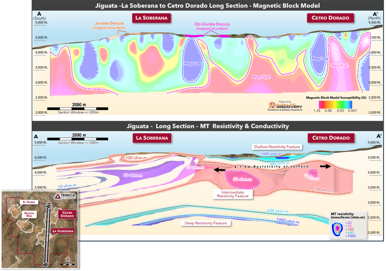
Click Image To View Full SizeFigure 5. Approximate north-south long section through the La Soberana and Cetro Dorado alteration centres, with results of the magnetic (Vertical Integral of the Analytic Signal) (top) and Magnetotelluric (MT) (bottom) 3D inversions.
Next Steps at Jiguata
Results of the Jiguata field program provide geological, geochemical and geophysical data that the Company interprets as consistent with its exploration model for a potential porphyry and high sulphidation epithermal environment at Jiguata, with alteration centres over an area of approximately 7km x 4km. The Company is now in the process of finalizing the integrated interpretation of the results and conducting targeting analysis for the maiden drill program.
La Higuera Drilling Update
At the Company’s La Higuera Project, a drill program comprising three diamond holes for a planned total of approximately 1,050m, was initiated at the Chirsposo Sur target, as previously announced in the news release of April 28, 2026. Two holes were designed to test discrete magnetic highs within the main magnetic and gravity target, with a third hole to the south to test a rare coincident low resistivity (<60 ohm.m) anomaly evident in the pole-dipole IP data.
The program has been expanded with an additional hole drilled into the southernmost discrete magnetic anomaly.
All four holes have been completed and assay results will be reported in due course as they are received from the laboratory.
Analysis and QA/QC Procedures
The geological interpretations described above for the four alteration centres are based on surface mapping, review of spectral datasets and geochemical statistical analysis. Only limited historic drilling has been completed to date, and there can be no assurance that the interpreted mineralized systems will be confirmed through future exploration programs.
The technical information presented in this release is based on geological mapping, surface geochemical sampling, spectral analysis and geophysical surveys completed across the Jiguata Project during 2026 as well as analysis of previous soil and rock geochemical sampling. Geological mapping and surface sampling were completed by independent geological consultants Asesorias Geomineras, with sampling locations, geological observations and alteration features recorded in the field and subsequently compiled for interpretation.
Soil and rock chip samples collected during the field program were submitted to ALS Patagonia (“ALS”) in Copiapó, northern Chile, for multielement geochemical analysis. A suite of reference standards and duplicates were inserted and submitted with each batch, comprising approximately 10% of the total sample count. The soil samples were analyzed using the ME-MS61L method with gold analyzed by method Au-AA23. The rock samples were analyzed using the ME-MS61 method with gold analyzed by method Au-AA23. The rock chip and soil samples were subject to spectral analysis, also completed by ALS, using a Terraspec instrument, with processing of the spectral data by consultant group GlobalOreAdvisory Pty Limited (“GlobalOre”), based in Brisbane, Australia, using proprietary methods. Geochemical and spectral datasets were compiled and reviewed using ioGAS software and were subject to internal QA/QC review, including checks of sample data, analytical results, spatial relationships and consistency with mapped geology and alteration observations. Areas interpreted as transported surface material or volcanic units with potential to mask underlying hydrothermal responses were considered separately during interpretation.
The Company’s geochemical interpretations remain preliminary, as multielement analytical results have been received for 314 of the 672 soil samples collected, together with all 149 rock chip samples. Additional results, once received, will be reviewed and incorporated into the Company’s geological and geochemical interpretation.
Ground magnetic data collected over the Jiguata Project in early 2026 by Argali Geofísica were further processed using Vector Residual Magnetic Intensity filtering and analytic signal-based products, including the Vertical Integral of the Analytic Signal, to improve geological interpretation in the project’s low magnetic latitude setting. The processed magnetic data were used to support 3D magnetic inversion modelling and interpretation of magnetic basement architecture, magnetic depletion zones and potential lithological or alteration-related features.
The magnetotelluric survey completed over the Jiguata Project was conducted by Southernrock Geophysics and finalized in May 2026. The MT data were processed and modelled using 3D inversion techniques to assess subsurface resistivity variations. MT responses are not diagnostic of mineralization and have been interpreted in the context of lithology, alteration, structure and potential hydrothermal fluid pathways.
Qualified Person
All scientific and technical information in this press release has been prepared by, or approved by, Dr. Paul Gow, who is the CEO of Tribeca Resources. He is a Member of the Australian Institute of Geoscientists (MAIG), a Member of the Australasian Institute of Mining and Metallurgy (MAusIMM) and a qualified person for the purposes of National Instrument 43-101 – Standards of Disclosure for Mineral Projects (“NI 43-101”). Dr. Gow has not verified any of the information regarding any of the properties or projects referred to herein other than the Jiguata and La Higuera Properties. Mineralization on any other properties referred to herein is not necessarily indicative of mineralization on the Jiguata or La Higuera Properties.
About Tribeca Resources
Tribeca Resources is a portfolio-driven copper explorer focused on northern Chile. Led by a team with a track-record of discovery and significant equity ownership, Tribeca Resources’ objective is to discover the mineral resources for the next generation of copper mines in Chile.
Tribeca Resources’ flagship La Higuera IOCG Project is 100%-owned and has seen approximately 10,000m of drilling with mineralization defined over a 1.4 kilometre strike length at the Gaby discovery. The Chiricuto and Jiguata projects are earlier stage porphyry copper-gold-molybdenum targets, held under purchase option agreements.
On behalf of Tribeca Resources Corporation
|
Paul Gow |
Thomas Schmidt |
|
|
CEO and Director |
President and Director |
|
|
+1 604 685 9316 |
+1 604 685 9316 |
Cautionary Note
Neither the TSX Venture Exchange Inc. nor its Regulation Service Provider (as that term is defined in the policies of the TSX Venture Exchange Inc.) accepts responsibility for the adequacy or accuracy of this press release.
This press release does not constitute or form a part of any offer or solicitation to purchase or subscribe for securities in the United States. The securities referred to herein have not been and will not be registered under the Securities Act of 1933, as amended (the “Securities Act”), or with any securities regulatory authority of any state or other jurisdiction in the United States, and may not be offered or sold, directly or indirectly, within the United States or to, or for the account or benefit of, U.S. persons, as such term is defined in Regulation S under the Securities Act (“Regulation S”), except pursuant to an exemption from or in a transaction not subject to the registration requirements of the Securities Act.
Forward-Looking Information
This press release contains forward-looking statements and information that are based on the beliefs of management and reflect the Company's current expectations. When used in this press release, the words "estimate", "project", "belief", "anticipate", "intend", "expect", "plan", "predict", "may" or "should" and the negative of these words or such variations thereon or comparable terminology are intended to identify forward-looking statements and information. The forward-looking statements and information in this press release include statements regarding the relationship between alteration and rock characteristics identified in geological mapping and potential mineralization, the relationship between geophysical and geochemical survey results and potential mineralization, the identification, prioritization and anticipated quality of exploration targets, the interpreted scale, extent and geological significance of alteration systems, the size and timing of the proposed 2026 drill programs, the integration of new and historic data to define drill targets, the anticipated completion of field activities and commencement of drilling (including the potential for weather-related delays), the ongoing engagement of GlobalOre and its impact on exploration outcomes, the anticipated effectiveness of exploration methodologies, the use of proceeds from recently completed financings, the ability to secure and maintain necessary permits and approvals and the operations and future plans of the Company, including potential additional drilling and property acquisitions.
Such statements and information reflect the current view of the Company. By their nature, forward-looking statements involve known and unknown risks, uncertainties and other factors, which may cause our actual results, performance or achievements, or other future events, to be materially different from any future results, performance or achievements expressed or implied by such forward-looking statements. Such factors include, among others, the ability of the Company to pay the purchase price and make any other payments required under the Jiguata Option, risks associated with mineral exploration, including the risk that actual results of exploration will be different from those expected by management and that geological, geophysical and geochemical interpretations may not be confirmed by drilling, the preliminary nature of the Company’s exploration data and interpretations, including the risk that additional assay, geochemical, spectral or geophysical results may not support, or may modify, the Company’s current interpretations, the risk that geophysical anomalies may be caused by factors unrelated to mineralization, the risk that the Company’s targeting analysis may not result in the identification of drill targets or that drilling, if completed, may not result in the discovery of mineralization, risks of delays or interruptions to exploration activities due to weather, logistical or access issues, risks related to obtaining and maintaining necessary permits and approvals, risks related to the availability and retention of key personnel, the ability to raise additional capital, fluctuations in commodity prices and market conditions, the reliability of historic or third-party data, the risk that any mineralization identified may be limited in size, continuity or economic significance, unanticipated costs or environmental liabilities, the risk that new laws or regulations could adversely affect the business and results of operations of the Company and anticipated work on the Company’s projects and other risks inherent in early‑stage mineral exploration projects.
There are several important factors that could cause the Company’s actual results to differ materially from those indicated or implied by forward-looking statements and information. Such factors include, among others: reliance on key management; changes in the credit or securities markets; results of operating activities; unanticipated costs and expenses; fluctuations in commodity prices; and general market and industry conditions. The Company cautions that the foregoing list of material factors is not exhaustive. When relying on the Company's forward-looking statements and information to make decisions, investors and others should carefully consider the foregoing factors and other uncertainties and potential events.
The Company has assumed that the material factors referred to in the previous paragraph will not cause such forward-looking statements and information to differ materially from actual results or events. The forward-looking information contained in this press release represents the expectations of the Company as of the date of this press release and, accordingly, is subject to change after such date. Readers should not place undue importance on forward-looking information and should not rely upon this information as of any other date. While the Company may elect to, it does not undertake to update this information at any particular time except as required in accordance with applicable laws.
Copyright (c) 2026 TheNewswire - All rights reserved.