
Canstar Resources Intersects Potential VMS Feeder Zone at Mary March - 118 m of Copper- and Zinc-Bearing Stringer and Disseminated Mineralization Within Intervals Totalling 270 m of Altered Rhyolite
Toronto, Ontario--(Newsfile Corp. - July 8, 2026) - Canstar Resources Inc. (TSXV: ROX) ("Canstar" or the "Company") has encountered copper- and zinc-bearing sulphide stringers and disseminations over several apparently wide intercepts (true widths not yet determined) in the first diamond drill hole (MM-26-41) of its 2026 drill program at its flagship Mary March volcanogenic massive sulphide ("VMS") Project, in the Buchans district of central Newfoundland — its first drilling there since 2019. The drill hole intersected the targeted prospective rhyolite — the top of the mineralized package, where stringer mineralization was first encountered — at a downhole depth of 390.6 metres (an interpreted vertical depth of approximately 328 metres), essentially where the Company's 3D model predicted, and traced a total of 271 metres of altered, sulphide-bearing host rock through to an interpreted mineralized basal contact at 710.6 metres downhole (an approximate vertical depth of 568 metres). The rhyolite is interrupted by two magnetic dacitic intrusions of 40 and 9.1 metres thickness. Sulphide stringers with visually identified sphalerite occur at less-than-one-metre intervals in the upper 118 metres of the rhyolite and less frequently in the remainder, while disseminated pyrite is abundant (3-5%) in the lowermost 90 metres of the rhyolite. At 710.6 metres the rhyolite is in contact with a basaltic breccia containing red chert fragments and sulphide stringers containing sphalerite and chalcopyrite. The sulphide mineralization has the potential to be part of a feeder zone for a VMS deposit. The mineralization described in this news release is based on visual core logging and is preliminary; assays are pending.
Based on previous exploration, the mineralized rhyolite is a large target: interpreted to be continuous for approximately 1.2-1.3 kilometres along strike (approximately 700 metres confirmed by drilling) and roughly 200-300 metres thick (in part structurally thickened), and open along strike and at depth. Mineralization is present as stringers and disseminations through the rhyolite and as sphalerite- and chalcopyrite-bearing sulphides at its basal contact, so the Company regards the entire thickness as prospective. A system of this scale has the potential for more than one massive sulphide lens within it.²
Bob Patey, P.Geo., Vice President, Exploration of Canstar, commented: "The first drill hole of this program has provided an indication of potential thickness of the rhyolite at Mary March and identified a new area of strong alteration with base-metal sulphides on its southeast margin. This confirms the prospectivity of the additional license optioned in January: the alteration zone at Mary March extends into this ground, and a new zone of strong alteration occurs on the southeast side of the rhyolite."
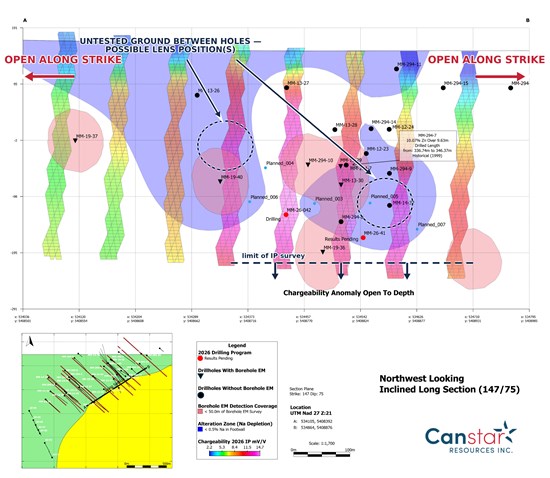
Figure 1. Northwest-looking inclined long section (147°/75°) through the Mary March target: 2026 induced-polarization (IP) chargeability (mV/V) along drill traces, footwall sodium-depletion alteration, and borehole-electromagnetic (BHEM) detection coverage, with holes coded by BHEM status. The interpreted system does not reach surface and remains open at depth and along strike, with untested ground between holes that could host one or more massive-sulphide lenses. Chargeability and alteration are interpretations; no grade or economic value is implied. Historical hole MM-294-7⁴ shown for context. Source: Canstar Resources Inc.
To view an enhanced version of this graphic, please visit:
https://images.newsfilecorp.com/files/1665/304380_269b658e2453a8b7_001full.jpg
Highlights
- MM-26-41 was targeted on the Mary March Thrust Fault and the rhyolite beyond. Past drilling at Mary March focused on a small area of the Mary March Thrust Fault, which forms the northwestern edge of the rhyolite. The core from this drilling and associated borehole electromagnetic surveys served to produce an alteration map of the rhyolite at the fault, which was supplemented by conductivity plots from the winter 2026 induced-polarization survey. The hole was aimed at an undrilled gap in this map and continued through the untested thickness of the rhyolite.
- Geological model supported by the first drill hole of the 2026 program. MM-26-41 entered the targeted rhyolite at 390.6 metres downhole — within roughly 10 metres of the depth predicted by the Company's 3D geological/geophysical model.
- Thick, altered, sulphide-bearing host rock. Drill-core intervals totalling approximately 271 metres of altered rhyolite carrying sulphide stringers and disseminations, drilled to its interpreted base — a long interval consistent with a large, long-lived hydrothermal system. The strongest, most continuous sulphide stringer development is over the uppermost approximately 118 metres, with strong alteration of a more chloritic character and a greater abundance of sulphide minerals in the bottom 30 metres, and base-metal sulphides below the contact. These are apparent widths; true widths and grades are not yet known.
- Both copper and zinc sulphides present. Stringers and disseminations of pyrite with visible sphalerite (zinc sulphide), chalcopyrite (copper sulphide) and galena (lead sulphide) have been confirmed by portable XRF spot analysis. The presence of copper is interpreted as a proximal, higher-temperature signal within the system. Assays are expected in approximately eight weeks.
- Favourable horizon is mineralized. At 710.6 metres downhole, the rhyolite meets the underlying mafic volcanic breccias at a contact interpreted to be primary (depositional) and locally marked by clasts of jasper (red chert). This contact is the same time-stratigraphic position as some of the VMS deposits at Buchans where the distinctive Intermediate Footwall Zone serves as a marker. A distinctive unit which may be equivalent is seen at 739-743 metres. The base-of-rhyolite setting, copper- and zinc-bearing sulphides, and possible Intermediate Footwall marker together support the existence of a specific surface to vector along strike, up dip and down dip.
- Strikingly similar stratigraphy to Buchans³. An independent litho-geochemical study, integrating 312 new whole-rock analyses with the Company's detailed core logging, concludes the Mary March volcanic succession may be a lateral stratigraphic equivalent of the Buchans succession or a very similar VMS-bearing succession — closely comparable in volcanic composition, magmatic affinity and hydrothermal alteration.
- Large, preserved, open system. The defining geophysical (induced-polarization, or "IP") anomaly does not reach surface - suggesting that the system is unlikely to have been eroded away and the prospective horizon may be preserved at depth — and the anomaly remains untested at depth and along strike beyond the surveyed area. A borehole-electromagnetic ("BHEM") survey and further drilling will follow.
- Drill hole MM-26-42 has begun. Collared approximately 100 metres southwest of MM-26-41, the new hole is aimed at a different undrilled gap in the map of the rhyolite below the Mary March Thrust Fault and will continue to test the full thickness of the rhyolite.
Mineralization has been identified from visual core logging and portable-XRF and is preliminary; these observations are not a substitute for assays and may differ materially. Intervals are apparent (core) widths; no grade is reported or implied. Interpretations of contacts, the basal-contact and footwall-marker horizons, and mineralization style remain subject to verification by the Company's Qualified Person. Readers should not assume economically significant mineralization is present. Assays are pending.
The mineralized horizon lies at an approximate vertical depth of 568 metres (710.6 metres downhole). To reach it, MM-26-41 was drilled as an inclined hole from accessible ground near the target — testing this priority target and drilling through the full prospective rhyolite package to its interpreted basal contact. Because the target was drilled obliquely, the drill hole's realized (down-hole) length of 757 metres is considerably greater than its vertical depth. The Company has identified shallower targets on the property which may be drilled in the future, subject to access to suitable drill pads.
Mary March project: highly prospective and underexplored
MM-26-41 supports the Company's view that a potentially extensive, high-grade VMS system exists at Mary March:
- Among the best historic intercepts in the belt outside the Buchans mine⁴ — the historic discovery hole at Mary March intercepted 9.63 m of 10.1% Zn, 0.64% Cu, 1.8% Pb, 122 g/t Ag and 4.2 g/t Au (MM-294-7); and 0.91 m of 16.8% Zn, 5.4% Pb, 660 g/t Ag and 12.2 g/t Au (MM-294-11) (Phelps Dodge, 1999-2000).
- Sulphides at surface⁴ — In 2019, Canstar identified a zone of interest approximately 1.7 kilometres northeast of the current drilling, where a 4.5-metre-thick bed of conglomerate carries centimetre-scale clasts of copper-bearing massive sulphide, with grab samples grading up to 5.7% Cu (Canstar, 2019). A separate historic boulder sample approximately 100 metres from the sulphide clasts returned 2.3% Cu, 27.8% Pb, 3.7% Zn and 63 g/t Ag (BP Resources, 1992).
- Large footprint — alteration and copper-zinc soil anomalies along a structural trend continue approximately 5 km to the northeast of the current drilling, largely untested.
- A district known for high grade⁴ — the past-producing Buchans mine, approximately 20 km west of Mary March, produced 16.2 million tonnes grading 14.5% Zn, 7.6% Pb, 1.33% Cu, 126 g/t Ag and 1.37 g/t Au from 1928 to 1984, ranking among the highest-grade VMS camps ever mined.
- And now drill hole MM-26-41 — a long interval through a potential copper- and zinc-bearing feeder zone drilled to a mineralized horizon which may form part of the base of a VMS deposit.
In the Company's view, the focus at Mary March is no longer on whether a high-grade VMS system formed, but on locating potentially multiple massive sulphide deposits — the horizon intercepted is interpreted to be part of a mineralized zone that was displaced along the Mary March Thrust Fault. Locating the parts of the mineralized zone is the objective of the 2026 program.
Notably, in the Buchans district, stringer-style mineralization has itself supported a defined mineral resource on a separate property⁴ — a reminder that the copper- and zinc-bearing mineralization intersected in MM-26-41 could be a meaningful result in its own right, not only a vector toward a potential massive-sulphide lens. No mineral resource has been established on the Company's mineral licenses.
Historical and third-party results are historical/selective in nature, have not been verified by the Company's Qualified Person, and are not necessarily indicative of mineralization on the Company's property.
An independent stratigraphic comparison with Buchans
A litho-geochemical study of the Mary March prospect by Dr. Rodney Allen of Volcanic Resources AB, integrating 312 new whole-rock analyses from the first eleven re-logged drill cores and four trenches with the Company's detailed core logging, has shown that the Mary March volcanic succession is strikingly similar to the stratigraphy of the nearby Buchans mining camp in three independent respects — volcanic composition, magmatic affinity and hydrothermal alteration (Figure 2). As at Buchans, the Mary March mineralization is associated with calc-alkaline rhyolite domes overlying a "transitional" footwall sequence, and the rocks display a classic VMS alteration pattern (proximal sericite-chlorite passing outward to albite).
The study concludes the Mary March area may be a lateral stratigraphic equivalent of the Buchans succession or a very similar VMS-bearing succession; in either case, the close similarity is considered highly encouraging for the discovery of high-grade VMS mineralization³. This is a key geological basis for the current program: the Company is drilling a succession that independent analysis indicates closely resembles the host of the Buchans historic ore.
Juan Carlos Giron Jr., President & CEO of Canstar, commented: "This is only our first hole at Mary March since 2019, and the results are very encouraging. After a year of rebuilding the geology and geochemistry and improving the land tenure, we drilled into what may be a thick, copper- and zinc-bearing feeder zone within about ten metres of where our model predicted, tracing it to the very horizon on which these deposits typically form. We have multiple lines of evidence here — historic high-grade intercepts, massive sulphide at surface, the structural picture, and now independent geochemical work showing our stratigraphy is strikingly similar to Buchans, roughly 20 kilometres away — these point to a fertile VMS system, and potentially more than one deposit, across this property. And because of the disciplined framework behind the program, every hole compounds: each new datapoint sharpens the model and our confidence in where to look next. The second hole is already underway."
With a potential copper- and zinc-bearing feeder zone and an interpreted mineralized basal horizon within a potentially large, largely intact hydrothermal system — in a volcanic succession independently assessed as strikingly similar to the Buchans stratigraphy — the Company's focus turns to vectoring toward the associated massive sulphides — the objective of the drilling now underway.
Figures and photographs
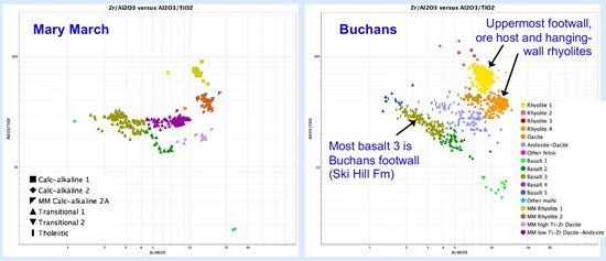
Figure 2. Volcanic composition of Mary March-Nancy April rock units (left) compared with the Buchans mine area data set (right), plotted as immobile-element ratios (Zr/Al₂O₃ versus Al₂O₃/TiO₂). The principal Mary March units — including the two rhyolites associated with mineralization — plot in positions closely comparable to their Buchans counterparts: one of three independent lines of litho-geochemical similarity between the successions³. Compositions are interpretations of litho-geochemical data; no grade or economic value is implied. Source: Allen (2026), Volcanic Resources AB.
To view an enhanced version of this graphic, please visit:
https://images.newsfilecorp.com/files/1665/304380_269b658e2453a8b7_002full.jpg
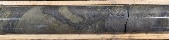
Photo 1. Pyrite stringer mineralization in altered rhyolite at approximately 414 metres down-hole in drill hole MM-26-41, within the approximately 118-metre interval of strongest stringer development¹.
To view an enhanced version of this graphic, please visit:
https://images.newsfilecorp.com/files/1665/304380_269b658e2453a8b7_003full.jpg
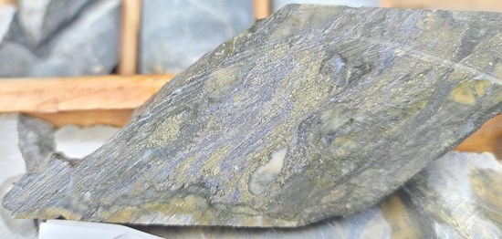
Photo 2. Cut core face at approximately 417 metres down-hole in MM-26-41: banded pyrite stringers with grey sphalerite in strongly altered rhyolite¹.
To view an enhanced version of this graphic, please visit:
https://images.newsfilecorp.com/files/1665/304380_269b658e2453a8b7_004full.jpg
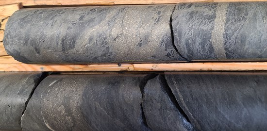
Photo 3. Sulphide stringers and disseminations in altered rhyolite drill core at approximately 433 metres down-hole in MM-26-41¹.
To view an enhanced version of this graphic, please visit:
https://images.newsfilecorp.com/files/1665/304380_269b658e2453a8b7_005full.jpg
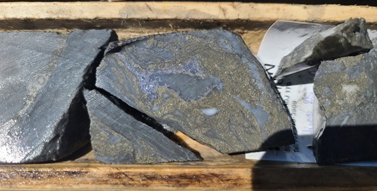
Photo 4. Base-metal sulphide mineralization at approximately 490 metres down-hole in MM-26-41: dark sphalerite with pyrite and quartz in altered rhyolite¹.
To view an enhanced version of this graphic, please visit:
https://images.newsfilecorp.com/files/1665/304380_269b658e2453a8b7_006full.jpg
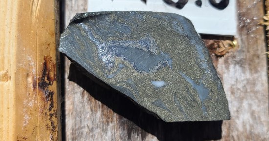
Photo 5. Detail of the approximately 490-metre specimen in Photo 4: a sphalerite-rich band rimmed by fine-grained pyrite¹.
To view an enhanced version of this graphic, please visit:
https://images.newsfilecorp.com/files/1665/304380_269b658e2453a8b7_007full.jpg
All photographs are of drill core from MM-26-41. Mineral identifications are visual (supported by portable-XRF spot readings), are preliminary and are not a substitute for assays¹; the photographs show selected intervals and are not necessarily representative of mineralization throughout the hole. Assay results are pending.
Other Company Updates
Further to its news release dated June 1, 2026, the Company has closed the previously announced acquisition contemplated by the definitive asset purchase agreement dated June 1, 2026 between the Company and 1478078 B.C. Ltd., doing business as Lithological Opportunities ("LithOps") (the "APA"), pursuant to which the Company acquired a 100% interest in three exploration permits in the northern Skellefte VMS district in Sweden.
In connection with closing of the transaction, the Company issued an aggregate of 15,000,000 common shares in the capital of the Company to LithOps at a deemed price of $0.035 per common share, in accordance with the terms of the APA. Cash consideration under the APA comprises a payment of $50,000, for which payment arrangements are being completed with LithOps, and a further $100,000 payable on or prior to the date that is twelve months following execution of the APA. The common shares issued to LithOps are subject to a statutory hold period of four months plus one day expiring on November 4, 2026, as well as applicable resale restrictions under the policies of the TSX Venture Exchange.
The exploration permits acquired by the Company pursuant to the APA comprise Missenträsk nr 101, Snotterberget nr 101 and Stöverberg nr 101, each located in the northern Skellefte VMS district in Sweden and valid through March 4, 2029. The acquired permits are subject to a 2.5% net smelter returns royalty in favour of LithOps. The Company has the right to repurchase up to 1.0% of the royalty in two tranches, consisting of 0.5% for $1,000,000 and an additional 0.5% for $2,000,000, following which the acquired permits would remain subject to a 1.5% net smelter returns royalty.
In addition, as previously disclosed, the Company, through LithOps acting on its behalf, applied for additional exploration permits adjacent to and around the acquired permits. Upon grant of the applicable permits by the Swedish Mining Inspectorate and completion of the applicable transfer steps, the additional permits are expected to be transferred to the Company in consideration for reimbursement to LithOps of staking costs of approximately $110,000, payable within 30 business days of receipt of supporting documentation. The additional permits are expected to be subject to a 1.25% net smelter returns royalty in favour of LithOps, of which the Company is expected to have the right to repurchase up to 0.5% in two tranches, consisting of 0.25% for $500,000 and an additional 0.25% for $1,000,000, following which the additional permits would remain subject to a 0.75% net smelter returns royalty.
The transaction is not a related party transaction and was not subject to shareholder approval.
Qualified Person
Bob Patey, B.Sc. (Hons.), P.Geo., Vice President, Exploration of Canstar and a Qualified Person as defined in National Instrument 43-101 - Standards of Disclosure for Mineral Projects, has reviewed and approved the scientific and technical information disclosed in this news release.
About Canstar Resources Inc.
Canstar Resources Inc. (TSXV: ROX) is a focused VMS exploration company with a portfolio of projects in established mining jurisdictions. The Company's flagship Mary March VMS Project (~122 km²) is located within the Buchans District in Central Newfoundland and is being advanced under a Phase 1 earn-in joint venture with VMS Mining Corporation. The Buchans mining camp is well-known for producing some of the highest-grade VMS deposits in North American mining history. The Company's Skellefte VMS Project (approximately 68,000 hectares) is located in the northern portion of the Skellefte VMS belt of Sweden, a well-established VMS district. Canstar also holds the Golden Baie Project in southern Newfoundland, currently subject to an option agreement with Churchill Resources Inc.
For further information, please contact:
Juan Carlos Giron Jr., President & Chief Executive Officer
Email: [email protected] | Phone: (647) 557-3442 | www.canstarresources.com
Canstar acknowledges the financial support of the Junior Exploration Assistance ("JEA") Program from the Government of Newfoundland and Labrador Department of Industry, Energy and Technology. Neither TSX Venture Exchange nor its Regulation Services Provider (as that term is defined in the policies of the TSX Venture Exchange) accepts responsibility for the adequacy or accuracy of this release.
References
Unless otherwise stated, all descriptions of mineralization, lithology, alteration, contacts and horizons in this news release — including the characterization of the intersected interval as a "VMS feeder zone," the interpreted primary (depositional) basal contact, the interpreted jasper (red chert) clasts and Intermediate Footwall marker horizon, and the down-hole continuity of mineralization — are based on visual examination of drill core and portable-XRF ("pXRF") readings and are preliminary and interpretive. Visual and pXRF observations are not a substitute for laboratory assays and may differ materially from assay results. Reported intervals are drill-core (apparent) widths; true widths are not yet known. No grade is reported or implied, and readers are cautioned not to assume that economically significant mineralization is present. Assay results are pending.
Dimensions of the mineralized rhyolite are interpreted and approximate. Drill-hole evidence from holes MM-13-25 through MM-294-12 supports an along-strike extent of approximately 700 metres, and a thickness of approximately 250 metres is supported by MM-26-41; the balance of the interpreted 1.2-1.3-kilometre strike length and 200-300-metre thickness range is based on the Company's 3D geological model and remains untested. True thickness is uncertain owing in part to structural thickening; "open" means untested. No grade or mineral resource is implied, and assay results are pending.
Allen, R. (Volcanic Resources AB), "Geological interpretation of litho-geochemical data from Mary March and Nancy April prospects, Buchans, Newfoundland," report dated 7 January 2026 — an independent litho-geochemical study based on 312 new whole-rock analyses from the first eleven re-logged drill cores and four trenches, together with 793 legacy analyses, integrated with the Company's geological core logging. The comparison with the Buchans camp is a litho-geochemical and core-logging interpretation. Information regarding the Buchans mine and other deposits is historical, is provided for geological context, has not been verified by the Company's Qualified Person, and is not necessarily indicative of mineralization on the Company's mineral licenses. No mineral resource has been established on the Company's mineral licenses.
Historical and third-party results referred to in this news release (including the Buchans mine production figures, the MM-294-series intercepts and the 2019 surface samples) are historical and/or selective in nature and predate, and were not prepared in accordance with, National Instrument 43-101. The Company's Qualified Person has not undertaken sufficient work to classify any historical result or estimate as a current mineral resource, and the Company is not treating any such historical result as a current mineral resource. Grab and clast samples are selective by nature and are not necessarily representative of the mineralization sampled. References to other deposits, districts and properties are provided for context and are not necessarily indicative of mineralization on the Project. Sources: historic Buchans production records (mine operated 1928-1984); MM-294-series drill results (Phelps Dodge, 1999-2000); 2019 surface sampling (Canstar); historic boulder sample (BP Resources, 1992).
Forward-Looking Statements
This news release contains "forward-looking information" within the meaning of applicable Canadian securities laws, including statements about the 2026 drill program, borehole-EM surveying, the orientation, depth and results of further drilling; the interpretation of contacts, horizons and structure; the interpreted dimensions of the mineralized rhyolite; the litho-geochemical comparison with the Buchans stratigraphy; the prospectivity of the interpreted horizon and the potential for one or more massive-sulphide lenses; the relevance of district and historical results to the Company's property; the completion of the remaining cash payments, and the grant and transfer of additional exploration permits, in connection with the Skellefte acquisition; and the earn-in joint venture with VMS Mining Corporation. Such information is based on management's current expectations and is subject to risks and uncertainties that may cause actual results to differ materially, including that visual and portable-XRF observations may not be confirmed by assay; that interpreted contacts, horizons and structures may differ; that historical and third-party results may not be indicative of results on the Company's property; the level and pace of funding under, and completion of the steps and conditions of, the earn-in agreement; and exploration, permitting, cost, market and commodity-price risks, together with the other risks in the Company's filings on SEDAR+. Readers should not place undue reliance on forward-looking information, which is given as of the date hereof; the Company undertakes no obligation to update it except as required by law.
To view the source version of this press release, please visit https://www.newsfilecorp.com/release/304380
Source: Canstar Resources Inc.