Northern Lights Defines Large Deep-Seated Copper Porphyry Intrusion with Correlated Anomalous Copper Geochemistry at Mt Horetzky Through Advanced 3D Magnetic Modelling
Vancouver, BC – June 11, 2026 – TheNewswire – Northern Lights Resources Corp. (CSE: NLR) (OTC: NLRCF) (FSE: 0ZH0) (“Northern Lights” or the “Company”) is pleased to report results of 3D inversion modelling of aeromagnetic survey data, from the Mt Horetzky copper porphyry intrusion, located within the Company’s Horetzky Copper Project in British Columbia’s Babine Porphyry Belt.
The 3D inversion provides a model of the deep structure of the Mt. Horetzky intrusive complex. When integrated with historical surface geochemistry, radiometrics and digital elevation model data, the results support the Company's porphyry-style copper exploration model and provide additional context for target refinement at Horetzky.
Project Overview
The Horetzky Copper Project is located in north-central BC in the Babine Porphyry Belt. Eocene (49 to 53 ma) biotite-feldspar intrusive stocks and dykes intrude Triassic to Early Cretaceous volcanic and sedimentary host rocks. Exploration is focussed on porphyry-style Cu (+Mo, Au-Ag) mineralization.
The project comprises 11 mineral claims for a total area of 5057.29 hectares, over which Northern Lights has an exclusive earn-in option. ARIS assessment reports on the claims are Good To December 22, 2028.
The Babine Porphyry Belt hosted two past producing copper mines (Bell and Granisle), and numerous significant occurrences at Morrison, Hearne Hill, and Duke . The Horetzky project has characteristics of the classical porphyry style deposit model, exemplified by the neighbouring NAK deposit operated by American Eagle Gold (TSXV:AE, OTCQB:AMEGF).
Horetzky was originally explored in the early 1900’s for silver associated with base metal veins. Exploration for porphyry-style mineralization restarted in the 1960’s with the discovery of the Bell and Granisle deposits. More recently, various operators have completed soil and rock sampling, ground and airborne geophysics, and a limited diamond drill programme of 8 shallow holes by Hecla Mining in 1973. Analytical results of drill core indicated widespread Cu mineralization spatially coincident with the core porphyry intrusion.
Regional Geology and Tectonics
The structural composition of the Babine Porphyry Belt likely reflects four significant tectonic events, including folding and uplift in response to the Stikinia-Cache Creek Terrane collision, mid-Cretaceous contraction causing northwest-trending folds and northeast-directed thrust faults, Late Cretaceous to Eocene crustal extension leading to grabens and horsts, and Eocene or younger northwest-southeast crustal extension involving tilting of fault blocks. The younger rocks typically occupy lower elevations, in contrast to older rocks forming ridge and mountain tops.
The majority of copper mineralization within the Babine Porphyry Belt is related to Babine Intrusions which are comprised of small plugs and dikes of crowded biotite ± hornblende feldspar porphyry, quartz ± biotite feldspar porphyry, and equigranular hornblende-biotite granodiorite to quartz diorite. Dated to the early Eocene (49 to 53 ma), these intrusions are considered the subvolcanic roots of a calc-alkaline magmatic arc, intruding Triassic to Early Cretaceous volcanic and sedimentary host rock strata.
Compositional similarities with the older Bulkley intrusions and Kasalka volcanic rocks suggest a trans-tensional volcanic environment during the Late Cretaceous and early Eocene. The predominant rock type in the Babine Intrusions is a crowded biotite-feldspar porphyry, occurring as small plugs, stocks and dikes. These intrusive bodies are primarily diorite to granodioritic in composition and presumably cut earlier equigranular granodiorite and quartz diorite stocks. Northeast to north trending dikes of biotite-feldspar porphyry often show associated copper mineralization and intense alteration. These stocks, associated with zones of biotite hornfels and disseminated pyrite, can host low-grade copper mineralization, with higher grades typically associated with younger porphyritic phases.
Project Geology
Outcrop in the Mt Horetzky project area is sparse due to widespread ovglacial and alluvial overburden, and much of the geology is inferred.
Mt Horetzky is underlain by a partially exposed diorite stock which has hornfelsed surrounding units. Later porphyry dykes are found cutting all units. Pyrite, chalcopyrite and molybdenite occur within the diorite, dykes and hornfelsed rocks as disseminations, fracture fillings and within quartz stockworks, with native copper and chalcocite also having been noted. Hornfelsed rocks are variably sericite altered and silicified and are leached, bleached and quartz stockwork in several areas.
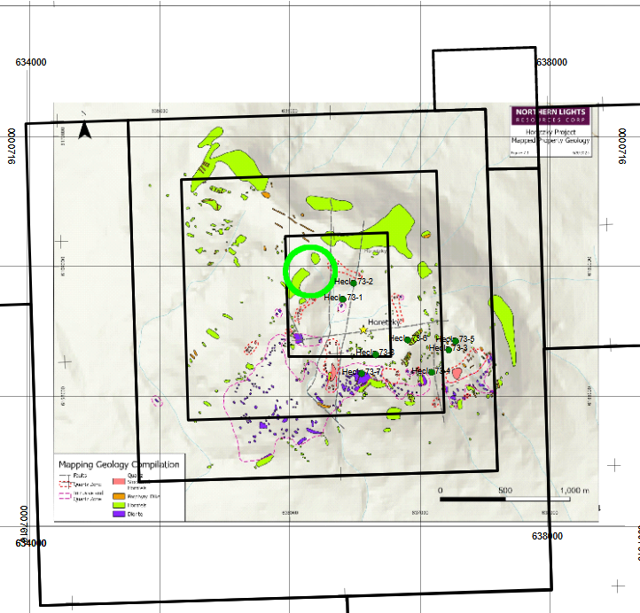
Diorite is typically weakly chlorite altered and ranges from a fine-grained biotite diorite to a medium grained sub-porphyritic biotite hornblende diorite. The most abundant type of dyke is a coarse-grained plagioclase biotite porphyry with a dark, fine-grained matrix. Although alteration within dykes is rarely intense and typically consists of fracture related chloritization, at least one dyke, located in an area of reduced magnetic susceptibility, is completely clay and quartz-sericite altered. Dikes and jointing typically trend northwest or northeast. Figure 7.1 illustrates the digitization and compilation of the property mapping programs done by Hecla in assessment reports 1576 and 2465, by Rio Algom in assessment report 22647, and data from CJL’s 2014 compilation.
Surface Geochemistry
Historical surface soil and rock sampling has been undertaken over multiple seasons, with inconsistent analytes and sample protocols, and non-standard QC. Surface geochemical data are considered as-is, with anomalies identified on a relative basis.
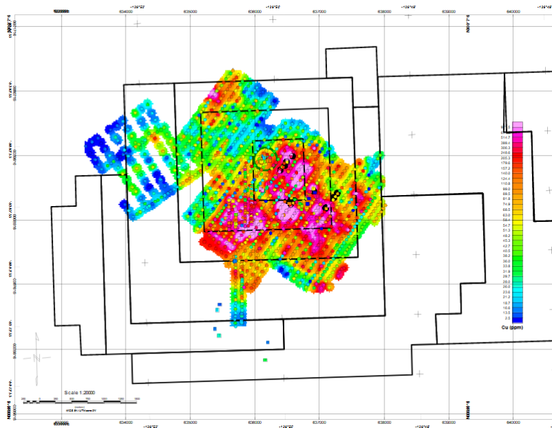
Surface geochemistry has outlined an anomalous Cu area of approximately 2x2.4km, which correlates spatially to the strongly magnetic porphyry intrusive body. The CJL showing discovered in 2014 is described as altered metavolcanic with disseminated and vein sulphides, with assays >1% Cu and 277.7 ppb Au, which is indicative of high grade portions within the mineral system.
Surface sampling has not covered the intrusive entirely, and extension of mineralization may continue to the south and west. In summary, the surface (rock and soil) geochemistry confirms widespread copper anomalism over a wide area, which supports the fertility and tenor of the mineralizing system.
Click Image To View Full Size
Cu Soils image illustrating 2X2.5km anomalous Cu area coincident with strongly magnetic porphyry intrusion
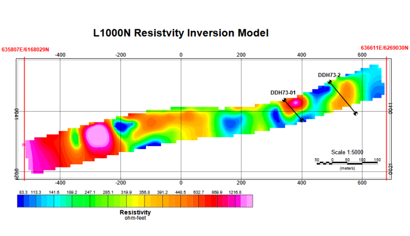
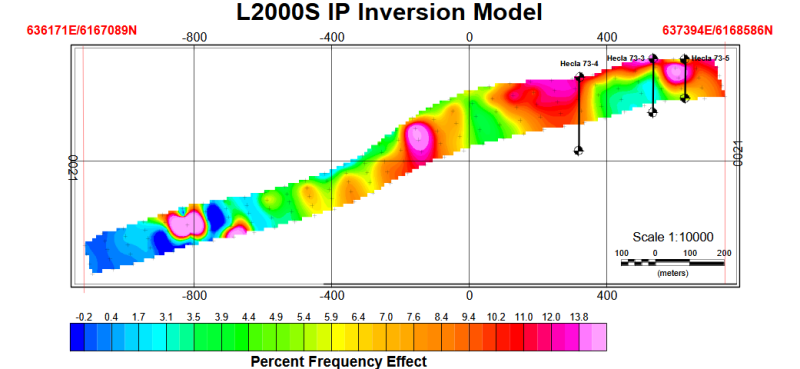
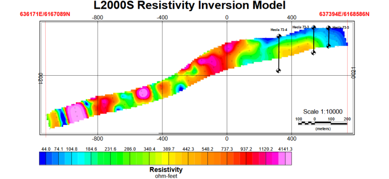
IP/Resistivity
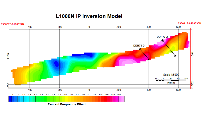
In 1972, McPhar Geophysics conducted an IP/Resistivity survey for Hecla Operating Company over the core of the Mt Horetzky porphyry intrusion. It appears though the historical drilling was focused on the area of anomalous Cu geochemistry, with drillhole targets on anomalous IP response. However, because the data were not inverted to “real earth” sections, the holes did not intersect the strongest IP response due to the inherent distortion of the electrode array pseudosections.
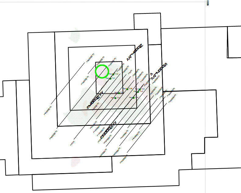
1972 historical IP/Resistivity survey location map with 200ppm Cu Soils (green) and 500ppm Cu rocks (red)
Click Image To View Full Size
Click Image To View Full Size
Click Image To View Full Size
Click Image To View Full Size
Terrain
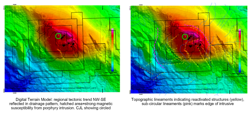
Digital Elevation Models (DEM) reflect subsurface features such as faults, surface drainage, and resistance to weathering which are important to interpretation of surface geochemistry, geologic mapping, and structure. The DEM over Mt Horetzky (https://maps.canada.ca/czs/index-en.html#PRODUCT_LIST0) indicates a topographic high over the east half of the porphyry intrusion caused by differential weathering of silicification in the alteration halo related to the porphyry system.
Many lineaments in the DEM are rectilinear, reflecting the general NW-SE tectonic fabric. Crosscutting and sub-circular lineaments are related to the discordant porphyry intrusion, and reflect the contact of the intrusive with the host rocks, and surrounding alteration zones. Prominent cross-cutting topographic lineaments may reflect deep-seated structures which have propagated to surface, and act as conduits for mineralizing hydrothermal fluids.
Click Image To View Full Size
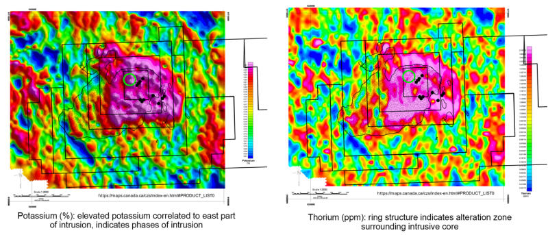
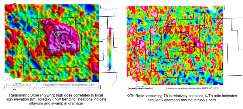
Radiometrics
Radiometrics is essentially a surface geochemical survey. Natural radioactivity has little depth penetration through surficial material. However, the radiometric response from outcrop or residual soils is indicative of source rock composition or alteration. Potassium is particularly important in mapping K alteration, which is characteristic of porphyry style mineralization.
At Horetzky, potassium is correlated directly to the highest elevation over the core intrusive area, which suggests cover material has been eroded. High potassium is characteristic of the core alteration of the porphyry, and may indicate the outer alteration ring.
Counter to the fact that radioactivity is essentially masked by overburden, linear potassium anomalies trending NW-SE likely represent compositional variations in the host rock. Areas with no radiometric response are related to water bodies (lakes and swamps).
Click Image To View Full Size
Click Image To View Full Size
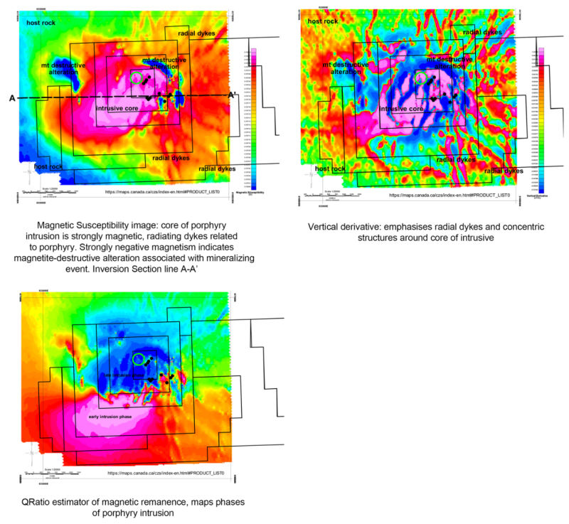
Magnetics
An airborne magnetics and HEM survey was conducted over the Horetzky area by Siegel and Associates in 1968, using Airphoto mosaics and strip chart recording. Due to the lack of digital navigation and mapping, results were not digitally compiled. However, it was noted that the Horetzky intrusive has a strong magnetic signature, and some EM anomalies were identified.
The project area was subsequently flown in 2021 by Precision Geosurveys for Volatus Capital Corp., and included magnetics and radiometrics. The survey by Precision is the basis for interpretation in this report.
There are two main methods of interpretation of magnetic data for mineral exploration: 2D Mapping (filtering and derivatives), and 3D inversion. In either case, the geological interpretation is inferred without direct measurement of physical properties (most importantly magnetic susceptibility and remanence).
The magnetic susceptibility is related fundamentally to the amount of iron-rich minerals in a rock, but also to the metamorphic, alteration, and thermal history. Magnetic susceptibility is therefore not a direct indicator of lithology.
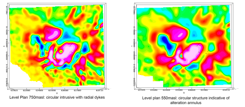
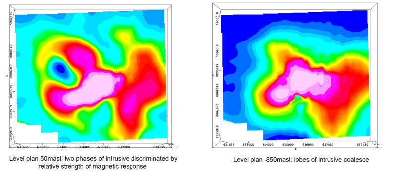
The magnetic susceptibility distribution over the Mt Horetzky project identifies four magnetic domains
-
Domain 1 (host rock)– low susceptibility, NW-SE banding indicates regional tectonic fabric.
-
Domain; 2 (radial dykes)- moderate susceptibility linear bands radiating from core intrusion.
-
Domain 3 (early intrusive) – moderate, flat susceptibility.
-
Domain 4 (late porphyry intrusion core) – discordant, strong susceptibility, multiple intrusion phases. Combined with geochemistry, the late phase intrusion with magnetite destructive alteration is mineralised.
Click Image To View Full Size
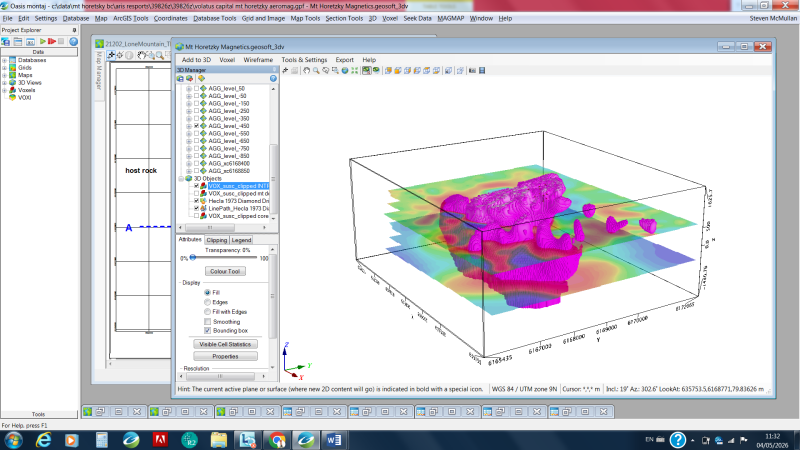
3D Voxel Inversion
Voxel inversion has become a common technique in magnetic interpretation for visualisation of 3D form and structure. The inversion process calculates the magnetic susceptibility of volume elements in a 3D grid, and iteratively changes the parameters to match the observed data.
Click Image To View Full Size
3D perspective view looking NW: pink polygon = volume of late stage strongly magnetic porphyry, level plans at 500m and -450m masl
The 3D Voxel model indicates several characteristics of the Mt Horetzky intrusive:
-
The intrusive has several intrusive phases, the latest phase having stronger magnetic susceptibility
-
Radial dykes appear at shallow depth, indicating the level where the dynamic pressure of the intrusion exceeds the host rock confining pressure
-
The intrusive root extends to more than 2500m from surface, at the limit of the inversion depth
Click Image To View Full Size
Click Image To View Full Size
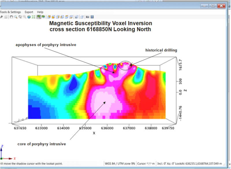
Cross Section 6168850N Interpretation
Strongly magnetic massive body caused by deep-seated intrusive from 500masl to total inversion depth of -1500masl. Narrow strongly magnetic fingers represent apophyses from the intrusive core. These apophyses are manifested at surface as radial dykes.
Click Image To View Full Size
Vertical Section 6168850N: large strongly magnetic intrusive body, shallow variable magnetic response of host rock volcanics and sediments. Model depth 3km
Key Findings Supporting the Exploration Model
Progress on development of an exploration model based on airborne geophysics include:
-
Strong magnetic signature of porphyry intrusion
-
Differentiation of two main phases of intrusion
-
Intrusion extends more than 2.5km from surface
-
Very weak magnetic susceptibility attributed to magnetite-destructive alteration
-
Topographic highs indicates silicification and resistant to weathering
-
Cu mineralization related to intrusive-host rock contact
Qualified Person
Steven McMullan, P. Geo. supervised the preparation of and reviewed and approved the scientific and technical information contained in this news release. Mr McMullan is a qualified person as defined by National Instrument 43-101 - Standards of Disclosure for Mineral Projects and is a director of the Company.
For Further Information
Luka Capin, Chief Executive Officer
Email: [email protected]
Tel: +1 647 625 8669
About Northern Lights Resources Corp.
Northern Lights Resources Corp is a growth-oriented exploration and development company advancing three key projects: the Horetzky Copper Project, located in the Babine Porphyry Belt of central British Columbia, the Pup Copper Project in the Yukon and the 100% owned, Secret Pass Gold Project located in Arizona. Northern Lights Resources trades under the ticker of “NLR” on the CSE on the OTC under the ticker “NLRCF” and on the on the FSE under the ticker symbol “0ZH0”. This and other Northern Lights Resources news releases can be viewed at www.sedarplus.ca and www.northernlightsresources.com.
Cautionary Statement Regarding Forward Looking Information
This news release contains forward-looking statements and forward-looking information within the meaning of applicable Canadian securities laws (collectively, “forward-looking statements”). Forward-looking statements include, but are not limited to the Company’s future exploration activities and corporate plans. Forward-looking statements are generally identified by words such as “anticipates”, “expects”, “intends”, “plans”, “believes”, or similar expressions, or statements that certain actions, events or results “may”, “could”, “would”, or “will” occur or be achieved. Forward-looking statements are based on the opinions and estimates of management as of the date of this news release and are subject to known and unknown risks, uncertainties and other factors that may cause actual results or events to differ materially from those anticipated in such forward-looking statements. These risks and uncertainties include, but are not limited to, risks related to exploration activities, changes in market conditions, and other risks described in the Company’s public disclosure filings available on SEDAR+. Readers are cautioned not to place undue reliance on forward-looking statements. The Company does not undertake any obligation to update or revise any forward-looking statements except as required by applicable securities laws.
References
Arndt, R, 2026: 2025 Geological and Geochemical Assessment Report on the Horetzky Copper Project, Omineca Mining Division, BC, Located Within: NTS Sheet: 093M/10, Work Centered at Approximately: Lat: 55° 38' 26.38" N, Long: 126° 49' 49.28" W UTM: Easting 636557.0E, Northing 6168222.0, NAD 83 Zone 9, for Northern Lights Resources Corp, Report Prepared by: Ralph Arndt B.S.c G.I.T Hardline Exploration Corp 7351 Cedar Rd, Smithers, B.C., Canada, V0J 2N2, 142p.
Bouzari, F, Lee, RG, Hart, CJR, and van Straaten, BI, 2022: Porphyry Vectoring Techniques in Advanced Argillic Altered Rocks of British Columbia, Geoscience BC Report 2022-03. MDRU Publication 456, 41p.
Clark, DA, 2013: Magnetic effects of hydrothermal alteration in porphyry copper and iron-oxide copper–gold systems: A review, Tectonophysics Volumes 624–625, 11 June 2014, Pages 46-65 , https://www.sciencedirect.com/science/article/pii/S0040195113007439
Clark, DA, 2017: Magnetic effects of alteration in mineral systems David A. Clark, Exploration '17 Petrophysics Workshop: 10-1, pp13.
Hallof, PG, and Goudie, MA, 1972: Report on the Induced Polarization and Resistivity Survey, Mount Horetzky Project, Omineca Mining Division, BC, ARIS report 03967, 39p.
Hallof, PG, and Goudie, MA, 1973: Report on the Induced Polarization and Resistivity Survey, Mount Horetzky Project, Omineca Mining Division, BC, ARIS report 04621, 33p.
Jacobs, A, 2025: Assessment Report 2025 Data Compilation Report on the Horetzky Property, Located in the Babine Lake Area North-Central British Columbia Omineca Mining Division On NTS 093M/10 BCGS 093M066, 093M067 Latitude 55° 38’ North and Longitude 126° 50’ West Project Operator Northern Lights Resources Corp, Property Owner Bernie Kreft Report Authored By Allan Jacobs July 3, 2025.
Kreft, B and Kreft J, 2024: Assessment Report 2024 Prospecting And Data Compilation Report On The Horetzky Property Located In the Babine Lake Area North-Central British Columbia Omineca Mining Division On NTS 093M10 BCGS 093M066, 093M067 Latitude 55° 38' North and Longitude 126° 50' West, 48p.
McMullan, SR, 2022: Technical Report Summarizing Exploration Work on the Nak Property, prepared for, American Eagle Gold Corp, ARIS Report No. 39933, 207p.
O'Brien, A, 2021, Airborne geophysics report, Longford Exploration Services Ltd, Lone Mountain Project, for Volatus Capital Corp, ARIS report 39826Z
Sillitoe, RH, 2010: Porphyry Copper Systems, Economic Geology, V105, pp3-41.
Copyright (c) 2026 TheNewswire - All rights reserved.