
Manhattan Uranium Identifies High-Grade Uranium Intercepts from 5,668-Hole Database Compilation at I-70, San Rafael District, Utah
Vancouver, British Columbia--(Newsfile Corp. - July 23, 2026) - Manhattan Uranium Discovery Corp. (TSXV: MANU) (OTC Pink: MAUUF) (FSE: JB50) ("Manhattan" or the "Company") is pleased to provide an update on ongoing technical work at its I-70 uranium project (the "I-70 Project" or "I-70"), located in the San Rafael uranium district of Utah. The Company has completed a major historical data compilation and digitization effort focused on building a modern drillhole and geological database for the I-70 Project.
The I-70 Project is located within the prolific Colorado Plateau uranium province and is permitted for underground mining. The Company believes this systematic compilation of historical data represents a critical step toward defining modern drill targets within a recognized uranium belt with established infrastructure.
Program Highlights
Major Database Established: Manhattan has consolidated approximately 5,668 historical drill collar locations from legacy project maps into a modern validated drillhole database. The compilation includes 4,550 historical gamma-equivalent uranium intervals across 2,769 drill holes, while additional non-assay interval coding was generated for modeling purposes to support geological correlation, barren/mineralized zone interpretation, and drill targeting.
Pervasive Uranium Mineralization Confirmed: Of 2,769 drill holes for which gamma data has been recovered to date, approximately 1,985 holes, or 72%, contain at least one historical gamma-equivalent interval of 0.10% eU₃O₈ or greater, demonstrating the widespread nature of uranium mineralization across the I-70 Project.
High-Grade Intercepts Recovered: Numerous high-grade historical intercepts have been identified through this review, including GR-896-80 returning 1.22 m at 1.59% eU₃O₈ and FC-20-67 returning 2.13 m at 0.86% eU₃O₈, all of which were absent from all prior digital records.
3D Uranium Targets Generated: An initial lithology model for the Salt Wash Member of the Morrison Formation has been integrated with the drillhole database and digitized underground workings to generate preliminary 3D uranium target domains across the I-70 project area.
Drill Program Planning Underway: Priority targets are now being defined for the upcoming field season, focused on areas where historical data indicates continuity of mineralized horizons and potential for unmined extensions within a recognized, infrastructure-rich uranium belt.
"The San Rafael area's uranium mining history spans more than seventy years, and this database work shows just how much of that endowment was never systematically followed up. At a time when the U.S. is racing to rebuild domestic uranium supply, having a district-scale, infrastructure-connected asset like I-70 positioned for near-term drill testing is exactly where we want to be," stated William Sheriff, Chairman of Manhattan.
"This compilation converts decades of legacy paper records into a targeting asset. A 72% mineralization hit rate across nearly 2,800 historical holes tells us I-70 was under-drilled by modern standards, and recovering intercepts like GR-896-80's 1.22 metres at 1.59% eU₃O₈ from records that predate digital exploration gives us a significant advantage in target definition moving forward," stated Galen McNamara, CEO and Director of Manhattan.
Overview
The Company has completed a major historical data compilation and digitization effort focused on building a modern drillhole and geological database for the I-70 Project. Work completed to date includes the consolidation, correction, and validation of historical drill collar, downhole survey, and gamma-equivalent uranium data from legacy project maps and records. The database now incorporates approximately 5,668 historical drill collar locations with corresponding downhole survey records. To date, the compilation includes 4,550 historical gamma-equivalent uranium intervals across 2,769 drill holes, with additional non-assay interval coding generated during database validation and 3D modeling to support geological correlation, barren/mineralized zone interpretation, and drill targeting.
Of the 2,769 drill holes for which gamma assay data has been recovered to date, approximately 1,985 — or 72% — contain at least one interval grading 0.10% eU₃O₈ or greater, demonstrating the widespread and pervasive nature of uranium mineralization across the I-70 Project. This hit rate is significant for a sandstone-hosted uranium district and underscores the mineral endowment of the I-70 Project area.
As part of this work, Manhattan has recovered and digitized numerous historical drill intercepts from legacy project maps that were not previously incorporated into the digital database. Several of these intercepts include elevated gamma uranium values that represent the best historical intersections at the I-70 Project.
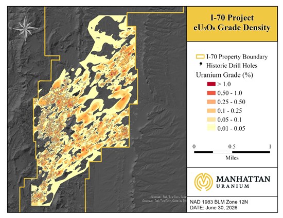
Figure 1: I-70 Project drill holes and eU₃O₈ grade density
To view an enhanced version of this graphic, please visit:
https://images.newsfilecorp.com/files/8126/306184_5bce43e0c4de6bea_001full.jpg
Selected High-Priority Historical Intercepts
The table below presents 100 high-priority historical intercepts identified to date from the Company's ongoing review of the database, ranked by grade-thickness (GT). The table excludes holes flagged as mined out, holes flagged within 5 m of known underground workings, intervals beginning at 0 m, and exact 1 m or 2 m intervals to avoid including interpreted interval artifacts. GT, expressed in %·m, is a standard exploration metric used across uranium districts to rank the combined significance of grade and interval width. These intercepts are historical in nature, transcribed from legacy project maps and records, and are being used for exploration targeting and 3D modeling purposes only. They have not yet been independently verified by the Company.
| Hole ID | From (m) | To (m) | Length (m) | eU3O8 (%) | GT (%·m) |
| GR-896-80 | 206.38 | 207.60 | 1.22 | 1.586 | 1.935 |
| FC-20-67 | 92.58 | 94.71 | 2.13 | 0.860 | 1.832 |
| GR-1324-81 | 208.30 | 210.74 | 2.44 | 0.390 | 0.952 |
| GR-984-80 | 246.31 | 247.98 | 1.67 | 0.569 | 0.950 |
| X374 | 4.28 | 8.70 | 4.42 | 0.200 | 0.884 |
| S-287 | 32.56 | 35.00 | 2.44 | 0.360 | 0.878 |
| GR-1277-81 | 214.00 | 215.83 | 1.83 | 0.460 | 0.842 |
| GR-1333-81 | 212.42 | 215.62 | 3.20 | 0.250 | 0.800 |
| GR-1261-81 | 193.88 | 194.49 | 0.61 | 1.300 | 0.793 |
| GR-734-80 | 208.35 | 208.96 | 0.61 | 1.300 | 0.792 |
| GR-35-76 | 216.74 | 217.20 | 0.46 | 1.700 | 0.782 |
| S-4-70 | 128.72 | 129.48 | 0.76 | 1.020 | 0.775 |
| GR-882-80 | 231.31 | 232.98 | 1.67 | 0.452 | 0.755 |
| T-424 | 51.76 | 53.14 | 1.38 | 0.540 | 0.745 |
| GR-1333-81 | 211.81 | 212.26 | 0.45 | 1.600 | 0.720 |
| GR-1311-81 | 170.35 | 172.64 | 2.29 | 0.310 | 0.710 |
| R-551 | 66.24 | 67.77 | 1.53 | 0.460 | 0.704 |
| T-909 | 75.21 | 76.43 | 1.22 | 0.570 | 0.695 |
| M-13 | 66.55 | 67.01 | 0.46 | 1.480 | 0.681 |
| G-16 | 135.58 | 136.19 | 0.61 | 1.110 | 0.677 |
| GR-274-78 | 243.63 | 244.08 | 0.45 | 1.500 | 0.675 |
| GR-1013-81 | 221.65 | 223.94 | 2.29 | 0.290 | 0.664 |
| T-212 | 2.29 | 3.66 | 1.37 | 0.480 | 0.658 |
| GR-1298-81 | 159.59 | 161.57 | 1.98 | 0.330 | 0.653 |
| HS-51 | 50.33 | 50.94 | 0.61 | 1.050 | 0.640 |
| A-12 | 137.53 | 138.44 | 0.91 | 0.700 | 0.637 |
| S-218 | 27.61 | 28.22 | 0.61 | 1.040 | 0.634 |
| K-185 | 9.24 | 10.31 | 1.07 | 0.590 | 0.631 |
| TL-57 | 43.81 | 44.88 | 1.07 | 0.570 | 0.610 |
| S-1-70 | 143.71 | 144.63 | 0.92 | 0.660 | 0.607 |
| S-169 | 40.58 | 41.90 | 1.31 | 0.460 | 0.603 |
| S-146 | 17.71 | 19.84 | 2.13 | 0.280 | 0.596 |
| GR-286-78 | 233.54 | 237.50 | 3.96 | 0.150 | 0.594 |
| GR-345-78 | 225.49 | 226.10 | 0.61 | 0.970 | 0.592 |
| R-520 | 46.86 | 48.23 | 1.37 | 0.430 | 0.589 |
| GR-719-80 | 168.58 | 168.89 | 0.31 | 1.900 | 0.589 |
| GR-768-80 | 145.48 | 146.85 | 1.37 | 0.420 | 0.575 |
| X-186 | 9.78 | 10.09 | 0.31 | 1.800 | 0.558 |
| S-14 | 134.72 | 136.25 | 1.53 | 0.360 | 0.551 |
| SR-9-07 | 150.94 | 152.16 | 1.22 | 0.450 | 0.549 |
| R-552 | 65.57 | 66.33 | 0.76 | 0.700 | 0.532 |
| T-872 | 66.45 | 67.85 | 1.40 | 0.370 | 0.518 |
| GR-888-80 | 224.55 | 225.16 | 0.61 | 0.840 | 0.512 |
| D-6 | 91.09 | 91.58 | 0.49 | 1.000 | 0.490 |
| GR-444-79 | 229.18 | 230.40 | 1.22 | 0.400 | 0.488 |
| GR-1098-81 | 165.57 | 166.63 | 1.06 | 0.460 | 0.488 |
| GR-1347-81 | 159.56 | 160.48 | 0.92 | 0.520 | 0.478 |
| S-325 | 36.97 | 37.27 | 0.30 | 1.590 | 0.477 |
| GR-1347-81 | 163.22 | 164.44 | 1.22 | 0.380 | 0.464 |
| X548 | 13.76 | 14.97 | 1.21 | 0.380 | 0.460 |
| GR-704-80 | 151.49 | 152.25 | 0.76 | 0.600 | 0.456 |
| K-177 | 10.20 | 10.97 | 0.77 | 0.590 | 0.454 |
| X-911 | 9.20 | 9.97 | 0.77 | 0.590 | 0.454 |
| HS-174 | 63.98 | 64.29 | 0.31 | 1.430 | 0.443 |
| GR-1088-81 | 220.89 | 222.11 | 1.22 | 0.360 | 0.439 |
| GR-518-79 | 116.13 | 118.11 | 1.98 | 0.220 | 0.436 |
| T190 | 5.62 | 6.69 | 1.07 | 0.400 | 0.428 |
| S-148 | 20.38 | 20.84 | 0.46 | 0.930 | 0.428 |
| GR-1262-81 | 183.52 | 184.74 | 1.22 | 0.350 | 0.427 |
| X-25 | 84.02 | 84.94 | 0.92 | 0.460 | 0.423 |
| SR-1 | 137.46 | 139.29 | 1.83 | 0.230 | 0.421 |
| T-953 | 119.84 | 120.60 | 0.76 | 0.550 | 0.418 |
| 16-D | 9.56 | 10.32 | 0.76 | 0.540 | 0.410 |
| GR-385-78 | 226.50 | 226.80 | 0.30 | 1.350 | 0.405 |
| GR-1076-81 | 114.80 | 116.48 | 1.68 | 0.240 | 0.403 |
| GR-216-78 | 234.53 | 234.98 | 0.45 | 0.890 | 0.400 |
| P-32 | 63.06 | 63.67 | 0.61 | 0.650 | 0.396 |
| GR-434-79 | 223.33 | 224.85 | 1.52 | 0.260 | 0.395 |
| T-873 | 67.00 | 68.38 | 1.38 | 0.280 | 0.386 |
| T-891 | 72.40 | 73.93 | 1.53 | 0.250 | 0.383 |
| K-61 | 6.04 | 7.57 | 1.53 | 0.250 | 0.382 |
| TZ-1 | 134.78 | 135.94 | 1.16 | 0.330 | 0.382 |
| GR-1020-81 | 240.91 | 241.52 | 0.61 | 0.618 | 0.377 |
| S-113 | 40.78 | 41.90 | 1.13 | 0.330 | 0.372 |
| S-112 | 41.28 | 42.89 | 1.62 | 0.230 | 0.372 |
| T-744 | 33.75 | 34.52 | 0.77 | 0.480 | 0.370 |
| GR-622-79 | 244.88 | 245.33 | 0.45 | 0.820 | 0.369 |
| T979 | 19.01 | 20.23 | 1.22 | 0.300 | 0.366 |
| X-585 | 8.14 | 8.75 | 0.61 | 0.600 | 0.366 |
| GR-1281-81 | 158.28 | 159.35 | 1.07 | 0.340 | 0.364 |
| S-2-70 | 143.71 | 144.32 | 0.61 | 0.590 | 0.360 |
| GR-824-80 | 188.03 | 190.01 | 1.98 | 0.180 | 0.356 |
| GR-39-76 | 218.21 | 221.56 | 3.35 | 0.106 | 0.355 |
| R-559 | 66.80 | 68.02 | 1.22 | 0.290 | 0.354 |
| GR-92-77 | 179.41 | 179.86 | 0.45 | 0.780 | 0.351 |
| GR-1402-83 | 230.95 | 231.56 | 0.61 | 0.570 | 0.348 |
| P-29 | 75.33 | 77.15 | 1.82 | 0.190 | 0.346 |
| TL-109 | 39.09 | 40.00 | 0.91 | 0.380 | 0.346 |
| P-20 | 44.85 | 45.49 | 0.64 | 0.540 | 0.346 |
| S-108 | 42.40 | 43.84 | 1.43 | 0.240 | 0.344 |
| GR-1330-81 | 209.67 | 211.04 | 1.37 | 0.250 | 0.343 |
| GR-1037-81 | 194.86 | 196.23 | 1.37 | 0.250 | 0.342 |
| GR-1364-81 | 203.72 | 204.33 | 0.61 | 0.560 | 0.342 |
| GR-377-78 | 211.56 | 212.78 | 1.22 | 0.280 | 0.342 |
| R-580 | 72.81 | 73.42 | 0.61 | 0.560 | 0.342 |
| GR-1258-81 | 191.75 | 192.97 | 1.22 | 0.280 | 0.342 |
| X-12 | 10.78 | 11.70 | 0.92 | 0.370 | 0.340 |
| HS-181 | 53.10 | 53.55 | 0.45 | 0.750 | 0.337 |
| T-248 | 20.03 | 20.64 | 0.61 | 0.550 | 0.335 |
| X-31-67 | 31.67 | 32.28 | 0.61 | 0.550 | 0.335 |
* eU₃O₈ = equivalent U₃O₈ from historical downhole gamma (radiometric) logging, not chemical assays. Values assume secular equilibrium; disequilibrium, if present, may cause them to over- or under-state true uranium grades. Historical and unverified — for exploration reference only.
** GT (grade-thickness) = eU₃O₈ (%) × interval length (m). Used for comparative ranking purposes only.
Geology and Project Context
The I-70 Project is located in the San Rafael uranium district of Utah, one of the most historically significant uranium-producing areas in the United States. Uranium mineralization at the project is hosted within the Salt Wash Member of the Morrison Formation, a fluvial sandstone unit that served as the primary host for uranium production throughout the Colorado Plateau during the 1950s to 1980s mining cycle. The district has a well-established history of high-grade uranium production and is underlain by documented infrastructure including roads, power, and historical mine workings.
The Company's lithology model is being used to constrain uranium-bearing horizons and to support 3D interpretation of gamma-defined mineralized trends. Using the updated drillhole database, digitized underground workings, and interpreted lithology model, Manhattan has begun generating preliminary 3D uranium target domains designed to identify areas where historical gamma intercepts, favorable stratigraphy, and underground development suggest potential for additional uranium mineralization.
Technical Work Completed to Date
- Consolidated historical drillhole collar, survey, and assay/gamma records into a modern digital database.
- Compiled approximately 5,668 drill collar locations and matching downhole survey records.
- Recovered additional historical gamma intercepts from legacy project maps not previously captured in the digital database.
- Added missing survey records where required using vertical-hole assumptions for legacy holes lacking survey data.
- Reviewed and corrected interval gaps, overlaps, duplicate records, and missing-value codes.
- Digitized historical underground workings for integration into the 3D geological model.
- Built an initial lithology model focused on the Salt Wash Member of the Morrison Formation.
- Generated preliminary 3D uranium target domains to guide follow-up drilling.
Next Steps
- Continued validation and reconciliation of historical gamma data with underground workings and modern exploration results.
- Refinement of the lithology model and 3D uranium target domains.
- Definition of priority drill targets for the upcoming field season.
- Recovery of additional historical data recovery and expansion of database as the review of legacy records continues.
Technical Disclosure
The historical drillhole and gamma data referenced in this news release were compiled from legacy maps and historical records believed to be reliable. The Company has not yet completed sufficient work to independently verify these data and/or results. In addition, historical gamma values may not be directly comparable to modern chemical assay results and are being used by the Company for exploration targeting and modeling purposes only. The Company encourages readers to exercise appropriate caution when evaluating these data and/or results.
No current mineral resource or mineral reserve estimate has been established at the I-70 Project.
The uranium grades in this news release are expressed as equivalent U₃O₈ (eU₃O₈) and are derived from historical downhole gamma-probe (radiometric) measurements, not chemical assays. Equivalent grades are calculated from gamma response and assume secular equilibrium between uranium and its radioactive decay products. Uranium in sandstone-hosted systems such as the Salt Wash Member is mobile and may occur in radioactive disequilibrium, in which case eU₃O₈ values may materially overstate or understate true uranium grades. The gamma-probe equipment, calibration standards, and conversion parameters used by the historical operators are not fully documented, and the Company has not independently verified the original measurements or conversions. Reported intervals represent downhole lengths, not true thicknesses. These historical values are used for exploration targeting and 3D modeling only. The Company encourages readers to exercise appropriate caution when evaluating these data and/or results.
Certain scientific and technical information relating to I-70 Project contained in this news release is derived from or referenced in the Technical Report dated May 4, 2026 (with an effective date of May 4, 2026) titled "NI 43-101 Technical Report on the I-70 Uranium Property, Emery County, Utah, United States" (the "Technical Report") prepared by Paul D. Richardson, M.Sc., SME RM and Douglas H. Underhill, PhD, MBA, CPG. Such information is subject to all of the assumptions, qualifications and procedures set out in the Technical Report and reference should be made to the full text of the Technical Report, a copy of which has been filed with the applicable securities regulators and is available under the Company's profile on SEDAR+ (www.sedarplus.ca).
Qualified Person