Gold Strike Announces Receipt of a 10-Year Class 3 Quartz Exploration Permit for Gold Strike One Project and Provides Commentary with Respect to Mineral Tenure
Highlights
- The Yukon government has issued a Class 3 Quartz Exploration Permit for the GS1 Project.
- The Permit has a 10-year term and allows construction of a camp to house up to 30 people.
- The Company is aware that Snowline Gold Corp. has disclosed that certain components of its proposed Valley Deposit mine development will overlay part of the GS1 Project. The Company intends to protect the integrity of its land package, while preserving all rights associated with the Permit and the quartz claims comprising the GS1 Project.
Vancouver, British Columbia--(Newsfile Corp. - May 12, 2026) - Gold Strike Resources Corp. (TSXV: GSR) (the "Company", "Gold Strike" or "GSR") has received a Class 3 Quartz Exploration Permit (the "Permit") for its Gold Strike One project (the "GS1 Project") from the Yukon Department of Energy, Mines and Resources.
The Permit was granted following a positive recommendation from the Yukon Environmental and Socio-economic Assessment Board and contains customary conditions to ensure environmental stewardship of the land and respect for traditional lifestyles and activities of the First Nation of Na-Cho Nyäk Dun ("FNNND") on whose traditional territory the GS1 Project is located. The Permit provides the right to conduct advanced exploration work on the GS1 Project, including drilling, and is valid for a 10-year term.
Peter Miles, Chief Executive Officer of Gold Strike, commented, "Receiving the Class 3 Exploration Permit is a major step for Gold Strike and is expected to allow the Company to ramp up its exploration efforts in 2026 and beyond. The 2026 exploration program will significantly expand soil sampling across the entire property while focusing on the anomalous areas already identified. Concurrently, the Company will seek to systematically sample outcrop in the anomalous zones. This work, coupled with an extensive geophysical program, will define drill targets for future drill programs."
GS1 Project
The Company believes that the GS1 Project is highly prospective for a RIRGS-type deposit.1 The GS1 Project is located approximately 225 km east of Mayo and comprises 107 contiguous quartz mineral claims totalling 5,510 acres (2,230 hectares), situated immediately adjacent to the south, west and north of Snowline Gold Corp.'s ("Snowline") Valley Deposit.
The southern boundary of the GS1 Project lies less than 500 metres south of the southern extent of the Valley Deposit (see Figure 1 below) interpreted resource pit as defined in Snowline's preliminary economic assessment report entitled "Independent Preliminary Economic Assessment for the Rogue Project - Yukon, Canada" ("Snowline's PEA"), filed July 30, 2025 on Snowline's SEDAR+ profile and available at www.sedarplus.ca. Figure 1 also shows the Company's Gold Strike Two Project ("GS2 Project") relative to Snowline's Valley Deposit.
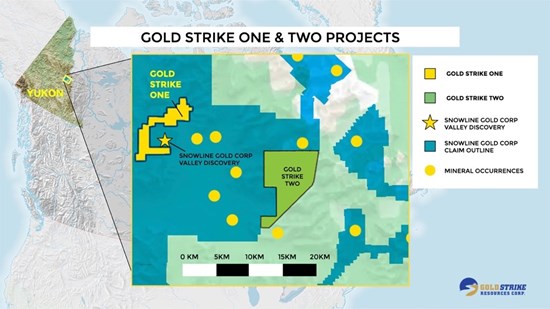
Figure 1: Location of the GS1 Project and GS2 Project
To view an enhanced version of this graphic, please visit:
https://images.newsfilecorp.com/files/2534/297090_25986de8748b9b9e_002full.jpg
New Camp
The Permit entitles the Company to construct a camp at the Project (the "Camp") to support exploration efforts during the term of the Permit. The Camp will have a capacity of up to 30 people and will also support the GS2 Project, 14 km to the east. The planned location of the Camp is shown in Figure 2 below. Work on the Camp is expected to commence in June 2026.
Project Integrity
Snowline's PEA identifies the 107 quartz claims comprising the GS1 Project as being located within Snowline's stated Rogue Project area and discloses proposed mine infrastructure overlaying that footprint (see Figure 2 below and Snowline's PEA Figures 18-2 and 18-3).2
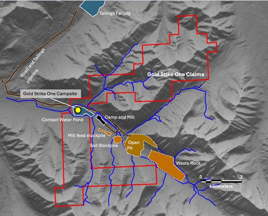
Figure 2: Proposed Snowline Valley Deposit infrastructure and GS1 Project Camp Locations
To view an enhanced version of this graphic, please visit:
https://images.newsfilecorp.com/files/2534/297090_25986de8748b9b9e_003full.jpg
| Supplemental legend: Red outline shows the GS1 Project Yellow dot shows the proposed Camp location |
Overlap with Proposed Snowline Infrastructure
The Company is aware that Snowline has disclosed that its proposed access route to the Valley Deposit will traverse, and certain proposed mine infrastructure will overlay, the GS1 Project. The Company is focused on advancing its own exploration plan and intends to protect the integrity of its land package and all rights associated with the Permit and the quartz claims comprising the GS1 Project. The Company will not acquiesce to the fragmenting of the GS1 Project to accommodate access to neighbouring developments. Snowline's PEA states that Snowline owns 38 placer claims (353 ha) in the vicinity of the Valley Deposit. Figure 3 below shows the GS1 Project quartz claims relative to Snowline's placer claims staked in the vicinity of the Valley Deposit (see also Figure 4-3 of Snowline's PEA).
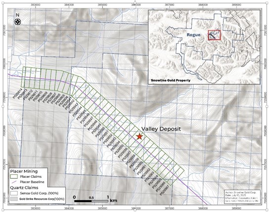
Figure 3: GS1 Project Quartz Claims and Snowline Placer Claims in the Vicinity of the Valley Deposit
To view an enhanced version of this graphic, please visit:
https://images.newsfilecorp.com/files/2534/297090_25986de8748b9b9e_005full.jpg
Placer Claims and Surface Rights
Section 4.2 of Snowline's PEA states that its placer claims "entitle claim holders to the surface rights, specifically the Au, above bedrock." That characterization does not appear to be consistent with placer tenure under Yukon law. While the overstaking of placer claims on top of quartz claims may be permitted if staked and used for the purposes in accordance with applicable Yukon laws, holders of placer claims are limited in what such claims permit under Yukon law. The Government of Yukon's Guidelines for Placer Claim Staking in Yukon3 (the "Placer Guidelines") state:
"Staking a placer claim does not give the claim holder surface rights or the exclusive rights to the land. Claims are not private property and you cannot build a permanent structure or residence on a claim. Placer claims cannot be used for commercial purposes (other than prospecting or placer mining) and the owner of a claim cannot give permission to a third party to occupy the surface for any purpose other than prospecting or placer mining."
Snowline's PEA expressly states, at Section 4.9.1, that "Surface rights would have to be obtained from the YG [Yukon Government] if the Project were to go into development." This is consistent with Gold Strike's position that Snowline's existing mineral tenure does not provide the surface rights required to construct or operate the mine infrastructure it proposes over the GS1 Project footprint, including the proposed site access road (Snowline's PEA at Section 18.1.1 and Figure 18-1) and contact water pond (Snowline's PEA Figures 18-2 and 18-3). Neither the access road nor the contact water pond constitutes placer prospecting or placer mining. Under the Placer Guidelines, a placer claim does not authorize permanent structures, permit commercial use beyond placer prospecting or placer mining, or entitle the holder to grant any third-party surface access for any non-placer purpose. Regardless of the purpose for which those placer claims were staked, any such assertion of surface rights is inconsistent with the scope of placer tenure. Gold Strike will not acquiesce to any assertion that Snowline's placer claims, staked over the GS1 Project's pre-existing quartz claim footprint, confer authority to construct, or operate mine infrastructure on that land. In any event, Gold Strike expects to defend the GS1 Project footprint against any encroachment on its quartz claim and Permit rights.
Technical Information