
Great Pacific Gold Expands High-Grade Elamaraka and Kargalio Gold Systems at Wild Dog
Vancouver, British Columbia--(Newsfile Corp. - August 13, 2026) - Great Pacific Gold Corp. (TSXV: GPAC) (OTCQX: GPGCF) (FSE: 0B3) ("Great Pacific Gold", "GPAC", or the "Company") reports new geological mapping and channel-sampling results from the Elamaraka and Kargalio vein systems (together, the "EK Target Area") within the southern Wild Dog structural corridor at its flagship Wild Dog Project in East New Britain Province, Papua New Guinea (Figure 1). The latest work has identified additional mineralized quartz-sulphide veins beyond the historically mapped areas, materially expanding the interpreted footprint of both systems and strengthening the Company's view that the southern corridor hosts multiple high-grade gold targets. The Company has also commenced its first push into the South Zone of the corridor, with earthmoving machinery advancing a new access track south of the EK Target Area and the exploration team mobilised to begin systematic work in this underexplored area.
Highlights - Elamaraka Vein System
Continuous channel sampling returned 9 m @ 4.81 g/t Au, 41.96 g/t Ag and 0.02% Cu from sulphide-rich quartz veining within the Elamaraka Vein System.
Peak assays include 26.86 g/t Au and 233.4 g/t Ag, and 8.72 g/t Au and 53.9 g/t Ag.
Separate quartz-sulphide vein exposures along the interpreted corridor returned 4.22 g/t Au (grab sample) and channel results of 1.20 g/t Au and 1.05 g/t Au, demonstrating mineralization across multiple vein occurrences.
Geological mapping identified multiple quartz-sulphide veins, significantly expanding the known footprint of the Elamaraka Vein System.
Highlights - Kargalio Vein System
Channel sampling defined approximately 6 m @ 7.29 g/t Au within a quartz-clay-sulphide vein, including 2 m @ 16.20 g/t Au across the Kargalio Vein.
A second 6 m channel interval approximately 40 m south of the main high-grade zone returned 2.85 g/t Au, 8.20 g/t Ag and 0.15% Cu, supporting the interpreted continuity of the Kargalio Vein System.
A newly discovered quartz-sulphide-clay crackle breccia zone approximately 260 m east of the Kargalio Vein returned approximately 10 m @ 1.77 g/t Au.
Recent mapping identified multiple additional quartz-sulphide veins with the same orientation and mineralization style as the historical Kargalio Vein, extending the known system well beyond the historical vein.
"The latest results materially strengthen our understanding of the southern Wild Dog corridor," stated Callum Spink, Chief Operating Officer and Vice President Exploration.
"Historical work reported high-grade gold mineralization at the EK Target Area. Our recent mapping and systematic sampling indicate that these prospects form part of broader mineralized corridors containing multiple quartz-sulphide veins. The combination of strong channel-sampling results, additional mineralized vein exposures and improving access provides a strong foundation for further target definition and future drill testing."
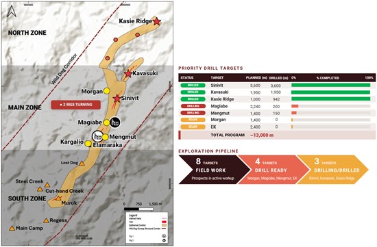
Figure 1: Simplified plan view of the 15 km Wild Dog Structural Corridor, showing the key epithermal target areas, current drilling locations, priority drill targets and the broader exploration pipeline from active field work through to drill-ready and drilling-stage prospects.
To view an enhanced version of this graphic, please visit:
https://images.newsfilecorp.com/files/11018/309396_fab989e1e4a8d88a_001full.jpg
Elamaraka Vein System - Mapping and Sampling
The Elamaraka Vein System is located approximately 2 km southwest of the Sinivit Deposit and forms part of the southern continuation of the Sinivit-Kavasuki epithermal corridor within the broader Wild Dog structural system. Discovered in 1983, historical trenching by previous operators returned up to 6 m @ 4.04 g/t Au1, establishing Elamaraka as a significant high-grade target. Historical exploration focused primarily on the principal vein exposure, leaving much of the surrounding structural corridor only partly evaluated.
Recent exploration assessed the historical vein together with adjacent mineralized exposures and interpreted extensions of the system. Continuous channel sampling across a sulphide-rich quartz vein returned 9 m @ 4.81 g/t Au and 41.96 g/t Ag (Figure 2). Gold and silver mineralization occurs throughout the sampled interval including 26.86 g/t Au and 233.4 g/t Ag (WDGS260796), 8.72 g/t Au and 53.9 g/t Ag (WDGS260797), 2.49 g/t Au and 15.4 g/t Ag (WDGS260798) and 1.64 g/t Au and 20.7 g/t Ag (WDGS260800).
The mineralized interval comprises massive quartz-sulphide veining containing abundant pyrite with minor chalcopyrite and bornite. Additional quartz-sulphide vein exposures along the interpreted structural corridor returned 4.22 g/t Au and 24.5 g/t Ag (WDGS260803), 2.21 g/t Au and 10.0 g/t Ag (WDGS260199), 1.20 g/t Au and 3.1 g/t Ag (WDGS260824) and 1.05 g/t Au and 8.4 g/t Ag (WDGS260804), demonstrating that gold mineralization occurs across multiple vein exposures.
The recent program has materially refined the geological interpretation of Elamaraka. Rather than a single historical vein, the Elamaraka Vein System is now interpreted as a broader mineralized corridor containing multiple quartz-sulphide veins with similar structural orientation and mineralization style. The mapped distribution of mineralized exposures enlarges the mapped footprint of the system and identifies new targets along strike and at depth.
High-grade surface mineralization is spatially associated with a west-dipping MobileMT resistive lineament interpreted to represent silicification and quartz-vein development (Figure 3). The feature extends to an interpreted depth of approximately 450 m, including approximately 160 m within the interpreted precious-metal zone, providing a compelling vector for evaluating continuity below surface and supporting prioritization for future drill testing.
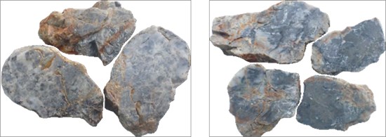
Plate 1 (left): Elamaraka Vein System channel sample WDGS260796 - 26.86 g/t Au, 233.4 g/t Ag, 176 ppm Cu. Plate 2 (right): WDGS260797 - 8.72 g/t Au, 53.9 g/t Ag, 206 ppm Cu.
To view an enhanced version of this graphic, please visit:
https://images.newsfilecorp.com/files/11018/309396_fab989e1e4a8d88a_002full.jpg
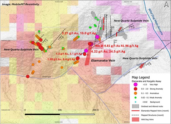
Figure 2: Updated plan map of the Elamaraka Vein System showing the historical vein, recent channel sampling, additional mineralized quartz-sulphide vein exposures, interpreted structures and surface assay results.
To view an enhanced version of this graphic, please visit:
https://images.newsfilecorp.com/files/11018/309396_fab989e1e4a8d88a_003full.jpg
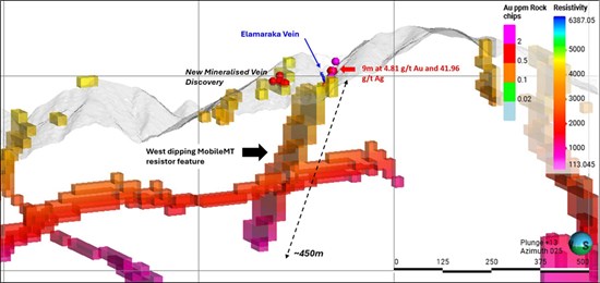
Figure 3: Cross-section through the Elamaraka Vein System showing the 9 m @ 4.81 g/t Au and 41.96 g/t Ag surface interval and its spatial relationship to the west-dipping MobileMT resistive lineament.
To view an enhanced version of this graphic, please visit:
https://images.newsfilecorp.com/files/11018/309396_fab989e1e4a8d88a_004full.jpg
Kargalio Vein System - Mapping and Sampling
The Kargalio Vein System is located immediately north of Elamaraka and represents one of the highest-grade historical vein targets within the southern Wild Dog corridor. Discovered in 1983, early dozer and hand trenching returned up to 6 m @ 11.9 g/t Au¹, establishing Kargalio as a priority exploration target and confirming high-grade gold mineralization well south of the main Sinivit-Kavasuki system.
Recent geological mapping and channel sampling have confirmed the high-grade nature of the Kargalio Vein System (Figure 4). A 6 m channel interval returned a weighted average of 7.29 g/t Au, 12.83 g/t Ag and 0.24% Cu, comprising 2 m @ 16.20 g/t Au (WDGS260976), 2 m @ 5.04 g/t Au (WDGS260977) and 2 m @ 0.62 g/t Au (WDGS260978).
Approximately 40 m south, a second 6 m channel interval returned a weighted average of 2.85 g/t Au, 8.20 g/t Ag and 0.15% Cu, comprising 2 m @ 3.11 g/t Au (WDGS260973), 2 m @ 0.05 g/t Au (WDGS260974) and 2 m @ 5.40 g/t Au (WDGS260975), supporting the interpreted continuity of the mineralized structure along strike.
A further quartz-sulphide-clay crackle breccia zone, located approximately 260 m east of the main Kargalio Vein, returned approximately 10 m @ 1.77 g/t Au, 4.74 g/t Ag and 0.01% Cu (WDGS260940 to WDGS260944), demonstrating that significant gold mineralization extends well beyond the historical vein into additional quartz-sulphide vein and breccia zones.
Gold mineralization is hosted by steeply dipping quartz-sulphide veins and quartz-sulphide-clay breccias containing pyrite with minor chalcopyrite and bornite. Mapping has identified multiple mineralized structures up to approximately 11 m in apparent width together with additional veins displaying the same northeast strike and steep northwesterly dip as the historical Kargalio Vein.
The latest work supports the interpretation of Kargalio as a broader mineralized corridor rather than a single historical vein occurrence. Continuous channel mineralization, additional mapped veins and a second mineralized zone 260 m east of the historical vein broaden the defined target footprint and highlight strong potential for further high-grade mineralization along strike and at depth.
Kargalio is also associated with a north-south trending MobileMT resistive feature which extends approximately 800 m along strike and to an interpreted depth of 420 m (Figure 5), providing a compelling framework for future drill testing.
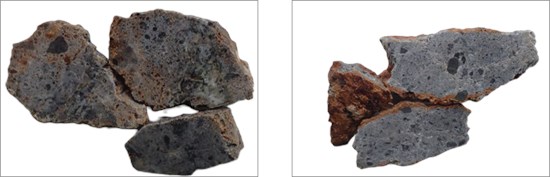
Plate 3 (left): Kargalio Vein System channel sample WDGS260976 - 16.20 g/t Au, 25.7 g/t Ag, 4,128 ppm Cu. Plate 4 (right): WDGS260977 - 5.04 g/t Au, 8.2 g/t Ag, 2,438 ppm Cu.
To view an enhanced version of this graphic, please visit:
https://images.newsfilecorp.com/files/11018/309396_fab989e1e4a8d88a_005full.jpg
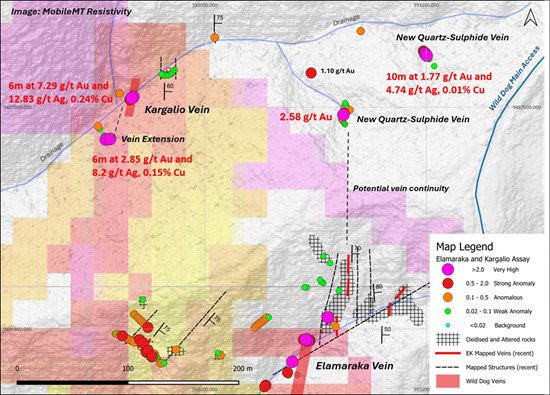
Figure 4: Updated plan map of the Kargalio Vein System showing recent channel lines, high-grade assay intervals, mapped quartz-sulphide veins, interpreted structures and the historical trench location.
To view an enhanced version of this graphic, please visit:
https://images.newsfilecorp.com/files/11018/309396_fab989e1e4a8d88a_006full.jpg
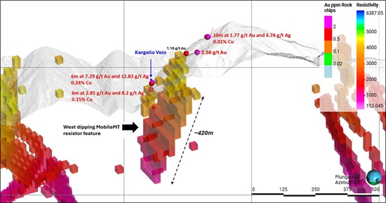
Figure 5: Oblique MobileMT resistivity view showing the vertically extensive resistive feature beneath the EK Target Area.
To view an enhanced version of this graphic, please visit:
https://images.newsfilecorp.com/files/11018/309396_fab989e1e4a8d88a_007full.jpg
Expanding Exploration Success Along the Southern Wild Dog Structural Corridor
The new results from Elamaraka and Kargalio demonstrate that high-grade mineralization in the southern Wild Dog corridor is not restricted to the historically documented vein exposures. Modern mapping and systematic channel sampling have identified multiple mineralized quartz-sulphide structures and extended the interpreted footprint of both systems.
These results also reflect the success of Great Pacific Gold's systematic exploration of the Main Zone, particularly south of the Sinivit Deposit, where detailed geological mapping and channel sampling have identified numerous previously unrecognized quartz-sulphide veins hosting significant gold mineralization along the targeted structural corridor (Figure 6). Together with the expanding EK Target Area, these discoveries reinforce the interpretation that the Sinivit-Kavasuki mineralized system forms part of a much larger district-scale hydrothermal system extending several kilometres to the south and provide a growing pipeline of high-quality exploration and drill targets.
Ongoing work will focus on extending geological mapping and channel sampling, integrating outstanding assay results, refining the structural interpretation and progressing access-track development farther south. These programs are designed to further define the geometry and continuity of the expanding vein systems and advance priority drill targets across the broader South Zone. With two diamond drill rigs already operating at Wild Dog and a growing pipeline of priority drill targets, the Company is well positioned to extend systematic drill testing into the southern corridor.
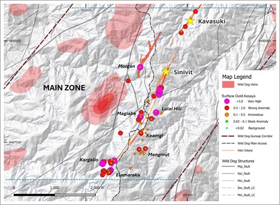
Figure 6. Significant surface gold assay results from recent mapping and sampling across the Main Zone of the Wild Dog structural corridor. Results identify multiple high-grade mineralized prospects distributed along the Main Zone from Kavasuki in the north to Elamaraka and Kargalio in the south, demonstrating the district-scale potential of the corridor.
To view an enhanced version of this graphic, please visit:
https://images.newsfilecorp.com/files/11018/309396_fab989e1e4a8d88a_008full.jpg
Advancing into the South Zone
Following the systematic exploration success across the Main Zone, the Company has commenced its first coordinated push into the South Zone of the Wild Dog structural corridor. Earthmoving machinery has cleared a new access track south of Elamaraka and Kargalio (Figure 8), and the exploration team has mobilised into the area to begin first-pass geological mapping and rock-chip sampling across the South Zone prospects, including Lost Dog, Steel Creek, Cut-hand Creek, Muruk and Regess (Figure 7).
Access development is a key enabler of systematic exploration in this underexplored section of the 15 km corridor. Results from the initial South Zone field program will be reported once assays have been received and reviewed.
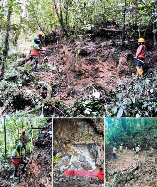
Figure 7: The Company's exploration team conducting first-pass geological mapping and rock-chip sampling of quartz vein outcrops in the South Zone of the Wild Dog structural corridor.
To view an enhanced version of this graphic, please visit:
https://images.newsfilecorp.com/files/11018/309396_fab989e1e4a8d88a_009full.jpg
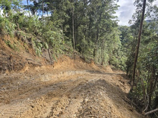
Figure 8: Newly cleared access track advancing south into the South Zone, opening the southern section of the corridor to systematic exploration.
To view an enhanced version of this graphic, please visit:
https://images.newsfilecorp.com/files/11018/309396_fab989e1e4a8d88a_010full.jpg
Notes:
- Historical exploration results referenced in this news release, including the historical trench results at Elamaraka and Kargalio, have not been independently verified by the Company and should not be relied upon as an indication of current or future mineral resources, mineral reserves or mineralization at the Wild Dog Project.
- Channel and rock-chip sample intervals reported in this news release represent sampled surface lengths. True widths are not known at this time.
- Rock-chip and grab samples are selective in nature and may not be representative of mineralization across the project or within the surrounding area.
- Silver values in this news release are reported from the PGGA03 analytical method and copper values from four-acid digestion ICP (method 4A/MS48), where available. Sample WDGS260199 was previously reported in the Company's news release dated May 27, 2026 using values from alternate analytical methods (10.2 g/t Ag and 465 ppm Cu); both sets of results are final laboratory values.
Table 1: Summary of selected surface sampling results and reported weighted channel intervals from the EK Target Area, southern Wild Dog structural corridor.
| Sample ID | Sample Type | Length (m) | Prospect | Au (g/t) | Ag (g/t) | Cu (ppm) | Geological Association | Reported In |
| WDGS260793 | Channel | 1 m | Elamaraka | 0.23 | 9.8 | 166 | Quartz-sulphide vein | 9 m @ 4.81 g/t Au, 41.96 g/t Ag, 0.02% Cu |
| WDGS260794 | Channel | 1 m | Elamaraka | 1.28 | 12.9 | 399 | Quartz-sulphide vein within mineralized fault zone | 9 m @ 4.81 g/t Au, 41.96 g/t Ag, 0.02% Cu |
| WDGS260795 | Channel | 1 m | Elamaraka | 1.27 | 22.7 | 263 | Quartz-sulphide vein within mineralized fault zone | 9 m @ 4.81 g/t Au, 41.96 g/t Ag, 0.02% Cu |
| WDGS260796 | Channel | 1 m | Elamaraka | 26.86 | 233.4 | 176 | Massive quartz-sulphide vein | 9 m @ 4.81 g/t Au, 41.96 g/t Ag, 0.02% Cu |
| WDGS260797 | Channel | 1 m | Elamaraka | 8.72 | 53.9 | 206 | Massive quartz-sulphide vein | 9 m @ 4.81 g/t Au, 41.96 g/t Ag, 0.02% Cu |
| WDGS260798 | Channel | 1 m | Elamaraka | 2.49 | 15.4 | 179 | Quartz-pyrite ± chalcopyrite ± bornite vein | 9 m @ 4.81 g/t Au, 41.96 g/t Ag, 0.02% Cu |
| WDGS260800 | Channel | 1 m | Elamaraka | 1.64 | 20.7 | 191 | Quartz-pyrite ± chalcopyrite ± bornite vein | 9 m @ 4.81 g/t Au, 41.96 g/t Ag, 0.02% Cu |
| WDGS260801 | Channel | 1 m | Elamaraka | 0.19 | 3.8 | 93 | Quartz-pyrite ± chalcopyrite ± bornite vein | 9 m @ 4.81 g/t Au, 41.96 g/t Ag, 0.02% Cu |
| WDGS260802 | Channel | 1 m | Elamaraka | 0.60 | 5.0 | 163 | Quartz-sulphide vein | 9 m @ 4.81 g/t Au, 41.96 g/t Ag, 0.02% Cu |
| WDGS260803 | Grab | - | Elamaraka | 4.22 | 24.5 | 794 | Sheeted quartz-pyrite ± chalcopyrite ± bornite vein | Standalone Result |
| WDGS260199 | Channel | 2 m | Elamaraka | 2.21 | 10.0 | 428 | Separate channel (~25-30 m NE) | Standalone Result |
| WDGS260804 | Channel | 2 m | Elamaraka | 1.05 | 8.4 | 380 | Massive quartz-sulphide vein | Standalone Result |
| WDGS260824 | Channel | 2 m | Elamaraka | 1.20 | 3.1 | 645 | Massive quartz-pyrite ± chalcopyrite ± bornite vein | Standalone Result |
| WDGS260911 | Channel | 2 m | Elamaraka | 1.30 | 5.9 | 152 | Silicified clay-quartz zone | Standalone Result |
| WDGS260973 | Channel | 2 m | Kargalio | 3.11 | 2.6 | 325 | Quartz-clay-sulphide vein | 6 m @ 2.85 g/t Au, 8.20 g/t Ag, 0.15% Cu |
| WDGS260974 | Channel | 2 m | Kargalio | 0.05 | 0.3 | 99 | Quartz-clay-sulphide vein | 6 m @ 2.85 g/t Au, 8.20 g/t Ag, 0.15% Cu |
| WDGS260975 | Channel | 2 m | Kargalio | 5.40 | 21.7 | 4,167 | Quartz-clay-sulphide vein | 6 m @ 2.85 g/t Au, 8.20 g/t Ag, 0.15% Cu |
| WDGS260976 | Channel | 2 m | Kargalio | 16.20 | 25.7 | 4,128 | Quartz-clay-sulphide vein | 6 m @ 7.29 g/t Au, 12.83 g/t Ag, 0.24% Cu |
| WDGS260977 | Channel | 2 m | Kargalio | 5.04 | 8.2 | 2,438 | Quartz-clay-sulphide vein | 6 m @ 7.29 g/t Au, 12.83 g/t Ag, 0.24% Cu |
| WDGS260978 | Channel | 2 m | Kargalio | 0.62 | 4.6 | 494 | Quartz-clay-sulphide vein | 6 m @ 7.29 g/t Au, 12.83 g/t Ag, 0.24% Cu |
| WDGS260940 | Channel | 2 m | Kargalio | 0.87 | 2.8 | 49 | Quartz-sulphide-clay crackle breccia | 10 m @ 1.77 g/t Au, 4.74 g/t Ag, 0.01% Cu |
| WDGS260941 | Channel | 2 m | Kargalio | 2.17 | 5.7 | 85 | Quartz-sulphide-clay crackle breccia | 10 m @ 1.77 g/t Au, 4.74 g/t Ag, 0.01% Cu |
| WDGS260942 | Channel | 2 m | Kargalio | 2.43 | 10.8 | 85 | Quartz-sulphide-clay crackle breccia | 10 m @ 1.77 g/t Au, 4.74 g/t Ag, 0.01% Cu |
| WDGS260943 | Channel | 2 m | Kargalio | 3.15 | 3.6 | 62 | Quartz-sulphide-clay crackle breccia | 10 m @ 1.77 g/t Au, 4.74 g/t Ag, 0.01% Cu |
| WDGS260944 | Channel | 2 m | Kargalio | 0.25 | 0.8 | 101 | Quartz-sulphide-clay crackle breccia | 10 m @ 1.77 g/t Au, 4.74 g/t Ag, 0.01% Cu |
| WDGS260958 | Channel | 2 m | Kargalio | 2.58 | 4.6 | 103 | Quartz-sulphide vein | Standalone Result |
| WDGS260979 | Grab | - | Kargalio | 1.10 | 0.8 | 57 | Quartz-clay-sulphide vein | Standalone Result |
On behalf of Great Pacific Gold:
Alex Heath
Chief Executive Officer
For further information, visit gpacgold.com or contact:
Investor Relations
Phone +1-778-262-2331
Email: [email protected]
Qualified Person
The technical content of this news release has been reviewed, verified and approved by Callum Spink, Chief Operating Officer and Vice President Exploration of Great Pacific Gold Corp., who is a Member of the Australian Institute of Geoscientists (MAIG) and a Qualified Person as defined by National Instrument 43-101 Standards of Disclosure for Mineral Projects. Mr. Spink has verified the GPAC-generated exploration data disclosed in this release, as applicable, by reviewing original assay certificates, sampling records, sample location data, QA/QC results and relevant geological and geophysical datasets. Mr. Spink is not independent of the Company. Historical exploration results have been reviewed against available historical reports and records but have not been independently verified through resampling or other confirmatory work. The Company considers the historical information relevant for exploration targeting but not sufficiently verified for use in mineral resource estimation.
Quality Assurance / Quality Control (QAQC)
The Company follows industry-standard quality assurance and quality control ("QA/QC") procedures for the collection, handling, preparation and analysis of exploration samples.
The Great Pacific Gold surface sampling results reported in this news release comprise rock-chip, grab and channel samples collected by Company geological personnel. Sample locations were recorded in the field, and samples were labelled, securely packaged and transported under the supervision of Company personnel to Intertek Minerals' sample preparation facility in Lae, Papua New Guinea. Intertek is independent of the Company. Intertek's Perth laboratory is accredited under ISO/IEC 17025 for the relevant analytical methods.
At the Lae facility, samples were dried, crushed and pulverized to produce a representative analytical pulp. Prepared pulps were then forwarded to Intertek's laboratory in Perth, Western Australia, for analytical testing. Gold was analyzed by fire assay. Silver values reported in this news release were determined using the PGGA03 analytical method. Copper and additional elements were analyzed using multi-element methods following four-acid digestion and ICP-OES and/or ICP-MS determination, including Intertek method 4A/MS48, as applicable. Samples returning results above the upper analytical limits of the initial method were reanalyzed using an appropriate overlimit method.
Great Pacific Gold inserts certified reference materials, blanks and duplicate samples into the sample stream at regular intervals to monitor analytical accuracy, contamination and sampling precision. Blank samples are also routinely inserted following visually mineralized or potentially high-grade samples. Laboratory internal quality-control samples are included as part of Intertek's analytical procedures. The QA/QC results associated with the surface-sampling results reported in this release were reviewed and were considered acceptable for the purposes of this disclosure.
Rock-chip and grab samples are selective in nature and may not be representative of the overall grade or extent of mineralization within the sampled area. Channel-sample intervals represent sampled surface lengths and may not be representative of mineralization at depth. True widths are not known at this time.
The historical exploration results referenced in this release predate Great Pacific Gold's involvement in the Project and were not collected under the Company's QA/QC procedures. Available historical records have been reviewed by the Qualified Person; however, the historical results have not been independently verified through resampling or confirmatory drilling and should not be relied upon as an indication of the existence, quantity or grade of current mineral resources or mineral reserves.
About Great Pacific Gold
Great Pacific Gold's vision is to become the leading gold-copper development company in Papua New Guinea ("PNG"). The Company has a portfolio of exploration-stage projects in PNG, as follows:
Wild Dog Project: the Company's flagship project is located in the East New Britain Province of PNG. The project consists of a large-scale epithermal target, the Wild Dog structural corridor, stretching 15 km in strike length and potentially over 1,000 metres deep based on a recent MobileMT geophysics survey. The survey also highlighted the Magiabe porphyry target, adjacent to the epithermal target and potentially 1,000 metres in diameter and over 2,000 metres deep. Drilling of the epithermal structure on the Sinivit target has yielded high-grade results, including WDG-08 which intercepted 8.4 metres at 50 g/t AuEq from 154 metres (see the Company's news release dated September 2, 2025 for details of the AuEq calculation parameters). The Company is currently conducting a two-rig diamond drilling program at Wild Dog.
Kesar Project: located in the Eastern Highlands Province of PNG and contiguous with the mine tenements of K92 Mining Inc. ("K92"), the Kesar Project is a greenfield exploration project with several high-priority targets in close proximity to the property boundary with K92. Multiple epithermal veins at Kesar are on strike and have the same orientation as key K92 deposits, such as Kora. Exploration work to date by the Company at the Kesar Project has shown that these veins have high grades of gold present in outcrop and very elevated gold in soil grades, coincident with aeromagnetic highs. The Company conducted a diamond drill program on key target areas at the Kesar Project from November 2024 to May 2025 and has developed a follow-up Phase 2 program for 2026.
Arau Project: also located in the Eastern Highlands Province of PNG, the Arau Project is south of and contiguous to the mine tenements of K92. Arau contains the highly prospective Mt. Victor exploration target with potential for a high sulphidation epithermal gold-base metal deposit. A Phase 1 Reverse Circulation drilling program was completed at Mt. Victor in August 2024, with encouraging results. The Arau Project includes the Elandora licence, which also contains various epithermal and copper-gold porphyry targets.
The Company also holds the Tinga Valley Project in PNG.
Forward-Looking Statements
Information set forth in this news release contains forward-looking statements that are based on assumptions as of the date of this news release. These statements reflect management's current estimates, beliefs, intentions and expectations. They are not guarantees of future performance. Great Pacific Gold cautions that all forward-looking statements are inherently uncertain and that actual performance may be affected by many material factors, most of which are beyond their respective control. Such factors include, among other things: risks and uncertainties relating to Great Pacific Gold's limited operating history, its exploration and development activities on its mineral properties and the need to comply with environmental and governmental regulations. Accordingly, actual and future events, conditions and results may differ materially from the estimates, beliefs, intentions and expectations expressed or implied in the forward-looking information. Except as required under applicable securities legislation, Great Pacific Gold does not undertake to publicly update or revise forward-looking information.
Mineralization at the properties held by K92 Mining Inc. is not necessarily indicative of mineralization at the Wild Dog Project.
Neither TSX Venture Exchange nor its Regulation Services Provider (as that term is defined in the policies of the TSX Venture Exchange) accepts responsibility for the adequacy or accuracy of this release.
To view the source version of this press release, please visit https://www.newsfilecorp.com/release/309396
Source: Great Pacific Gold Corp.