
Great Pacific Gold Commences Drilling High-Grade Surface Targets at Magiabe and Completes Current Kasie Ridge Program
Vancouver, British Columbia--(Newsfile Corp. - August 5, 2026) - Great Pacific Gold Corp. (TSXV: GPAC) (OTCQX: GPGCF) (FSE: 0B3) ("Great Pacific Gold", "GPAC", or the "Company") announces the commencement of diamond drilling at the Magiabe Vein target ("Magiabe") at its flagship Wild Dog Project (the "Project") in East New Britain Province, Papua New Guinea ("PNG"), following the completion of the current drilling program at the Kasie Ridge target ("Kasie Ridge").
The Company has relocated one of its two diamond drill rigs to Magiabe following the completion of the second Kasie Ridge drill hole. Magiabe is the fourth target to be drilled at Wild Dog in 2026 and forms part of the Main Zone drilling program for the second half of 2026, which is targeting approximately 8,000 metres of drilling across the Kavasuki, Magiabe, Mengmut, Morgan and EK targets (Figure 1). Located approximately 700 metres southwest of the historically mined Wild Dog deposit, Magiabe is interpreted to represent the southern continuation of the Wild Dog (Sinivit) vein system.
Highlights – Commencement of Drilling at Magiabe
- The first hole at Magiabe (MGH001) is underway. The initial program comprises up to 11 diamond drill holes for approximately 2,240 metres, designed to test the Magiabe and Magiabe West veins, with hole depths ranging from approximately 150 to 280 metres (Figure 2).
- Recent GPAC mapping and sampling identified the previously undrilled, high-grade Magiabe West Vein, approximately 100 m west of the main Magiabe Vein. Rock-chip samples returned up to 137 g/t Au, 76 g/t Ag and 3.97% Cu, while subsequent channel sampling returned 8.0 m @ 17.10 g/t Au, 7.63 g/t Ag and 0.67% Cu (18.24 g/t AuEq), including 3.0 m at 45.26 g/t Au, 20.33 g/t Ag and 1.78% Cu (48.3 g/t AuEq). See the Company's news releases dated February 19, 2026 and March 16, 2026.
- Historical trenching and drilling on the main Magiabe Vein returned up to 4.2 m @ 10.93 g/t Au, 1.6 m @ 23.0 g/t Au, 5.2 m @ 6.8 g/t Au and 4.4 m @ 9.23 g/t Au with 37.9 g/t Ag, highlighting the broader high-grade potential of the Magiabe vein system.
At Kasie Ridge, KAS02 has been completed to a final depth of 346.6 metres, concluding the current two-hole maiden drill program at the target. Assay, multi-element geochemical and XRD mineralogical results from both holes are pending.
"Magiabe is one of the strongest near-term drill targets in the Wild Dog corridor. We have high-grade mineralization exposed at surface at the newly identified Magiabe West Vein, encouraging historical trench and drill results from the main Magiabe Vein, and a clear structural model.
"The first two holes have been deliberately designed to answer the key geological questions quickly. MGH001 will test the interpreted geometry and continuity of the main Magiabe Vein from the preferred drilling direction, while MGH002 will provide the first drill test directly beneath the high-grade Magiabe West discovery. Together, these holes will give us an early indication of the scale, orientation and continuity of the multi-vein system and help guide the remainder of the program.
"With two rigs operating at Wild Dog and a strong pipeline of targets across the Main Zone, Magiabe represents an important next step in systematically testing the broader high-grade potential of the project," commented Callum Spink, COO & Vice President Exploration.
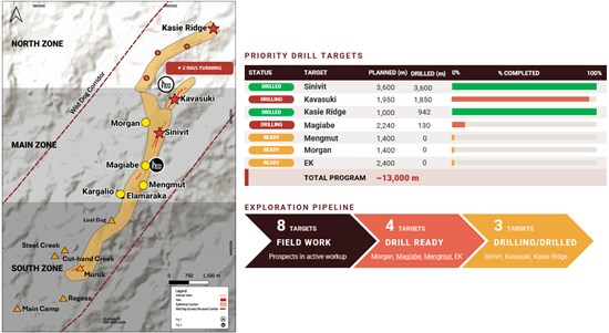
Figure 1: Simplified plan view of the 15 km Wild Dog Structural Corridor, showing the key epithermal target areas, current drilling locations, priority drill targets and the broader exploration pipeline from active field work through to drill-ready and drilling-stage prospects.
To view an enhanced version of this graphic, please visit:
https://images.newsfilecorp.com/files/11018/308078_b59b1e4824289b86_002full.jpg
Magiabe – Main Zone – Target Overview and Rationale
The Magiabe Vein Prospect is a structurally controlled, multi-vein epithermal Au–Ag–Cu quartz–sulphide system approximately 700–750 metres southwest of Sinivit. The prospect comprises the main Magiabe Vein, the recently discovered Magiabe West Vein and additional subparallel structures, developed along NE-trending, steeply dipping fault–shear zones with NW-trending cross-cutting structures interpreted to control the localisation of high-grade mineralization. Mineralization is hosted within altered Nengmutka Volcanics and comprises quartz–sulphide veins with pyrite, chalcopyrite, bornite, arsenopyrite and local telluride minerals – a metal association consistent with the broader Wild Dog epithermal system.
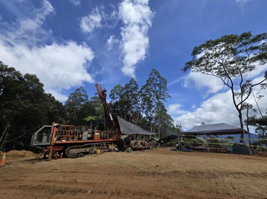
Figure 2: Photograph of drill rig (ZD01) established on the first drill pad (MGH001) at Magiabe.
To view an enhanced version of this graphic, please visit:
https://images.newsfilecorp.com/files/11018/308078_b59b1e4824289b86_003full.jpg
Historical exploration by previous operators included geological mapping, rock-chip sampling, trenching and limited drilling. Trenching across the main Magiabe Vein returned 4.2 m @ 10.93 g/t Au, and massive vein zones of 1.6 m @ 23 g/t Au and 5.2 m @ 6.8 g/t Au. Float and rock sampling in the Eramas Creek area returned results including 12.9 g/t Au with 151 g/t Ag, and 1.64 g/t Au with 410 ppm Te and 0.26% Cu, highlighting the telluride-bearing polymetallic character of the system.
Five diamond drill holes (90MGD001–005) were completed in 1990. The best result, 4.4 m @ 9.23 g/t Au and 37.9 g/t Ag from 29.2 m (90MGD004), confirmed high-grade mineralization at shallow depth, with additional intercepts including 2.20 m @ 1.59 g/t Au (90MGD002) and 1.35 m @ 0.85 g/t Au (90MGD003). Importantly, historical mapping and a review of the 1990 drilling indicate that the main Magiabe Vein dips moderately to steeply east (approximately 45–60°), and that the easterly inclined holes may have intersected the vein sub-parallel to the core axis – effectively drilling along the plane of the structure. Historical recommendations to drill from the west to test the true thickness and geometry of the vein were never carried out.
GPAC has been intensifying exploration at Magiabe since 2025, completing geological and structural mapping, rock-chip and channel sampling, and access track construction. This work culminated in the discovery of the Magiabe West Vein, a coherent high-grade Au–Ag–Cu structure approximately 100 metres west of the main vein, where rock-chip sampling of the discovery outcrop returned 137 g/t Au, 76 g/t Ag and 3.97% Cu; 123 g/t Au, 66 g/t Ag and 4.01% Cu; 113 g/t Au, 71 g/t Ag and 2.47% Cu; 90.9 g/t Au, 30 g/t Ag and 1.04% Cu; and 41.1 g/t Au, 31 g/t Ag and 4.29% Cu, with channel sampling returning 8.0 m @ 18.24 g/t AuEq. The Magiabe West Vein remains untested by drilling (Figures 4 and 5).
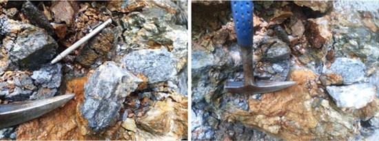
Figure 3: Magiabe West Vein discovery outcrop, showing brecciated quartz–sulphide mineralization within a silicified host. Visible sulphides occur along fracture surfaces and within the quartz matrix, consistent with a structurally controlled epithermal Au–Ag–Cu vein system.
To view an enhanced version of this graphic, please visit:
https://images.newsfilecorp.com/files/11018/308078_b59b1e4824289b86_004full.jpg
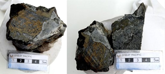
Figure 4: Cut hand specimens from the Magiabe West Vein discovery outcrop, displaying quartz–sulphide veining with visible semi-massive chalcopyrite and bornite mineralization. Scale bar in centimetres.
To view an enhanced version of this graphic, please visit:
https://images.newsfilecorp.com/files/11018/308078_b59b1e4824289b86_005full.jpg
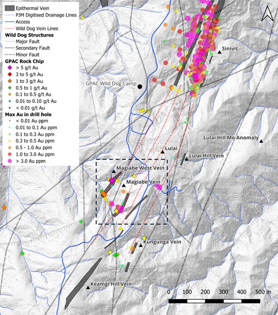
Figure 5: Location map of the Magiabe Vein Prospect within the southern Wild Dog–Sinivit structural corridor, showing interpreted epithermal vein trends, major structural features, historical drill hole gold anomalism and recent GPAC rock-chip sampling results. The Magiabe Vein and Magiabe West Vein occur along a northeast-trending mineralized corridor between the Wild Dog Camp area and the southern vein targets at Kungunga and Keamgi Hill.
To view an enhanced version of this graphic, please visit:
https://images.newsfilecorp.com/files/11018/308078_b59b1e4824289b86_006full.jpg
Drill targeting is further supported by geophysics. The 2010 3DIP survey defined a moderate to strong resistivity anomaly (approximately 750–1,500 ohm-m, evident from the 25 m to 75 m depth slices) spatially coincident with the Magiabe West Vein trend and mapped quartz vein outcrops, interpreted to represent zones of silicification and quartz vein development. MobileMT data show shallow resistive zones clustered around both vein systems to approximately 150 metres depth, with two deeper resistive features positioned beneath the near-surface 3DIP anomaly, a stacked response suggesting potential for vertically extensive silicification and quartz–sulphide vein development within the broader Magiabe structural corridor.
Initial Drill Plan – First Two Holes
The Magiabe drill program has been designed as a first-pass systematic evaluation of the Magiabe and Magiabe West veins, comprising up to 11 diamond drill holes for approximately 2,240 metres, with hole depths ranging from approximately 150 to 280 metres. The program has been designed with flexibility, with subsequent holes to be prioritised and adjusted based on the results of the initial drilling. The first two holes are designed to rapidly answer the two most important geological questions at the prospect (Figure 6).
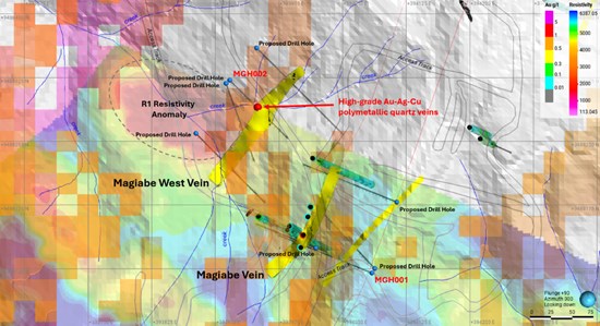
Figure 6: Integrated exploration plan of the Magiabe Vein System combining 3DIP resistivity, MobileMT resistivity, mapped quartz veins, historical drilling and proposed diamond drill holes, showing the locations of MGH001 and MGH002. Drilling is designed to test the continuity of high-grade Au–Ag–Cu polymetallic mineralization associated with coincident geophysical anomalies and interpreted structural corridors.
To view an enhanced version of this graphic, please visit:
https://images.newsfilecorp.com/files/11018/308078_b59b1e4824289b86_009full.jpg
MGH001 (280 m planned; -65° dip / 292° azimuth) is positioned on the eastern side of the prospect to test the main Magiabe Vein beneath its mapped surface exposures. The hole is the first westerly directed hole ever drilled at Magiabe and is designed to resolve the interpreted eastward dip of the vein, evaluate its geometry and continuity at depth, and test a favourable NW–NE structural intersection and coincident MobileMT resistivity anomaly (Figure 7). The principal interpreted target zone is between approximately 140 m and 230 m downhole, with potential for shallow mineralization from surface to approximately 50 m.
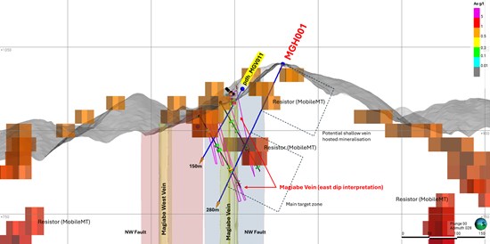
Figure 7: Cross section looking NE showing MGH001, designed to test the interpreted east-dipping geometry of the main Magiabe Vein and evaluate the continuity of Au–Ag–Cu quartz–sulphide mineralization at depth. The section highlights the interpreted Magiabe and Magiabe West vein systems, NW-trending fault structures, historical drill holes and coincident MobileMT resistive features.
To view an enhanced version of this graphic, please visit:
https://images.newsfilecorp.com/files/11018/308078_b59b1e4824289b86_010full.jpg
MGH002 (150 m planned; -50° dip / 135° azimuth) is designed to provide the first ever drill test of the Magiabe West Vein, targeting the structure approximately 35–50 metres directly beneath the high-grade discovery outcrop (Figure 8). The hole will evaluate the down-dip continuity, geometry and dip orientation of the vein and its favourable structural setting at the intersection of NE-trending vein structures and NW-trending cross-cutting faults, before continuing through the broader corridor to test for additional parallel vein zones that may be blind at surface.
The initial drilling is designed to test the continuity of high-grade Au–Ag–Cu mineralization at depth, improve understanding of the geometry of the multi-vein system, evaluate the relationship between mineralization and the MobileMT and 3DIP resistivity anomalies, and guide the design of subsequent drilling, with the potential to identify high-grade shoots analogous to those at the Wild Dog deposit.
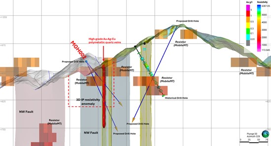
Figure 8: Cross section looking NE showing MGH002, designed to provide the first drill test of the Magiabe West high-grade Au–Ag–Cu polymetallic quartz–sulphide vein at depth. The hole targets the interpreted down-dip extension of the discovery vein and the coincident 3DIP resistivity anomaly, while also evaluating the broader mineralized structural corridor for concealed parallel vein zones.
To view an enhanced version of this graphic, please visit:
https://images.newsfilecorp.com/files/11018/308078_b59b1e4824289b86_012full.jpg
Table 1: Magiabe Planned Drill Hole Details – First Two Holes (PNG94 UTM Zone 56, GPS collar positions; listed in drill sequence).
| Drill hole | Easting | Northing | Elevation (m) | Dip (°) | Azimuth (°) | Planned Depth (m) |
| MGH001 | 394085.0 | 9488095.0 | 1019 | -65 | 292 | 280 |
| MGH002 | 393917.0 | 9488322.0 | 938 | -50 | 135 | 150 |
Kasie Ridge Update – Completion of KAS02
Drilling at Kasie Ridge has been completed for the current program, with the second drill hole, KAS02, finished at a final depth of 346.6 metres. KAS02 was collared approximately 315 metres south of KAS01 and oriented more perpendicular to the interpreted structural trends. The hole intersected what Company geologists visually interpret as some of the most intense alteration drilled at Wild Dog to date: below a shallow oxide cap, near-continuous silicification extends from approximately 41 metres to the end of the hole at 346.6 metres, including broad zones of massive replacement and chalcedonic silica with crackle-breccia textures, pervasive sericite-clay alteration, abundant disseminated to locally semi-massive pyrite, and visible native sulphur. These geological observations indicate an extensive zone of intense silicification and sulphide-bearing hydrothermal alteration, interpreted by Company geologists as consistent with a well-developed lithocap and supportive of the potential for an underlying high-sulphidation epithermal system. Assay, multi-element and mineralogical results are pending, and the observations reported here are visual and geological in nature.
Kasie Ridge, at the northern end of the Wild Dog structural corridor, is interpreted as a large preserved advanced argillic (lithocap-style) alteration system. The two completed drill holes represent the first drill test of the target and together provide two well-separated pierce points through the altered system, which will be integrated with the pending analytical results to guide any future work at the target.
A significant volume of analytical results from the Kasie Ridge program remains outstanding, including multi-element geochemistry and X-ray diffraction ("XRD") mineralogical analyses currently underway at Intertek's Perth laboratory. The XRD program comprises more than 90 selected core samples designed to characterise the vertical alteration zonation and clay mineral assemblages through the system. The Company expects to release a comprehensive Kasie Ridge update, incorporating the assay and mineralogical results for KAS01 together with initial results from KAS02, in late August 2026.
Figures 9 to 16 present representative drill core photographs from KAS02, shown in downhole order from 48.4 m to 238.07 m. Mineral identifications are visual and will be confirmed by the pending assay, multi-element and XRD dataset.
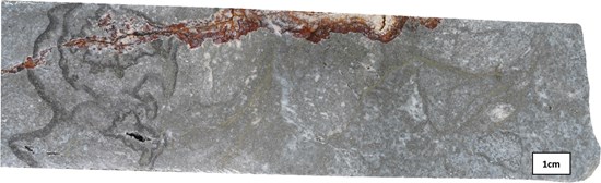
Figure 9: Intensely silicified crystal tuff at 48.4 m, with fine disseminated pyrite and hairline pyrite veinlets throughout; a hematite-stained, oxide-healed fracture cuts the upper edge of the sample.
To view an enhanced version of this graphic, please visit:
https://images.newsfilecorp.com/files/11018/308078_gpgcnine.jpg
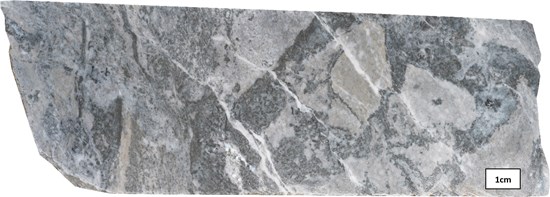
Figure 10: Brecciated, silica-overprinted sericite-altered crystal tuff at 69.4 m; fine dark sulphides and pyrite rim clasts and infill microfractures, cut by late white quartz-carbonate veinlets.
To view an enhanced version of this graphic, please visit:
https://images.newsfilecorp.com/files/11018/308078_gpgcten.jpg
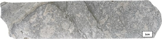
Figure 11: Pale grey silicified and argillic-altered volcaniclastic rock at 89.6 m, with fine disseminated pyrite and incipient crackle texture.
To view an enhanced version of this graphic, please visit:
https://images.newsfilecorp.com/files/11018/308078_gpgceleven.jpg
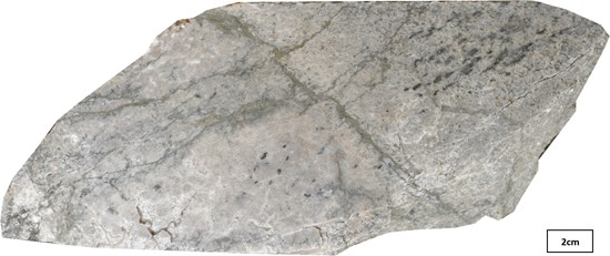
Figure 12: Silicified rock at 91.5 m cut by hairline pyrite stringers, with fine disseminated pyrite throughout.
To view an enhanced version of this graphic, please visit:
https://images.newsfilecorp.com/files/11018/308078_gpgctwelve.jpg
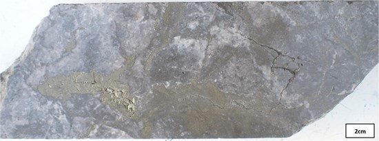
Figure 13: Crackle-brecciated, intensely silicified rock at 158.45 m, with pyrite forming irregular patches and veinlets, within the most sulphide-rich zone logged in the hole. Assay results are pending.
To view an enhanced version of this graphic, please visit:
https://images.newsfilecorp.com/files/11018/308078_gpgcthirteen.jpg
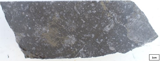
Figure 14: Silicified porphyritic andesite at 183.66 m, with relict feldspar phenocryst sites and fine disseminated pyrite.
To view an enhanced version of this graphic, please visit:
https://images.newsfilecorp.com/files/11018/308078_gpgcfourteen.jpg
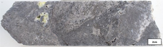
Figure 15: Silicified aphanitic-textured rock at 202.7 m, with blebs of native sulphur (yellow) – a texture considered consistent with the upper levels of a high-sulphidation epithermal system.
To view an enhanced version of this graphic, please visit:
https://images.newsfilecorp.com/files/11018/308078_gpgcfifteen.jpg
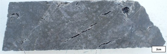
Figure 16: Dark grey, pervasively silicified rock at 238.07 m, with fine disseminated pyrite and hairline fractures, illustrating the persistence of intense silicification to depth.
To view an enhanced version of this graphic, please visit:
https://images.newsfilecorp.com/files/11018/308078_gpgcsixteen.jpg
Notes:
- The drill program described in this news release represents the planned initial program. Actual drill hole locations, depths, orientations and sequencing may be modified based on geological results, ground conditions, access and operational considerations.
- Drill intercepts and channel sample intervals reported in this news release represent core/sample lengths. True widths are not known at this time.
- Gold equivalent (AuEq) values are calculated using metal prices of US$2,000/oz Au, US$27.50/oz Ag and US$4.50/lb Cu. No metallurgical testing has been completed on Wild Dog mineralized samples. AuEq calculations assume recoveries of 92.6% Au, 78.0% Ag and 94.0% Cu, based on the recovery assumptions reported by K92 Mining in its Updated Definitive Feasibility Study for the Kainantu Mine.
- Historical exploration results have not been independently verified by the Company and should not be relied upon as an indication of current or future mineral resources, mineral reserves or mineralization at the Wild Dog Project.
- Rock-chip samples are selective in nature and may not be representative of mineralization across the project or within the surrounding area.
Table 2: Kasie Ridge Drill Hole Details (PNG94 UTM Zone 56 coordinates).
| Hole ID | Easting | Northing | RL | Dip | Azi | Max Depth (m) | Status |
| KAS01 | 396599.60 | 9493496.50 | 595.00 | -69 | 100 | 595.7 | Complete |
| KAS02 | 396582.80 | 9493182.80 | 674.00 | -68 | 114 | 346.6 | Complete |
On behalf of Great Pacific Gold:
Alex Heath
Chief Executive Officer and Director
For further information, visit gpacgold.com or contact:
Investor Relations
Phone +1-778-262-2331
Email: [email protected]
Qualified Person
The technical content of this news release has been reviewed, verified and approved by Callum Spink, Chief Operating Officer and Vice President Exploration of Great Pacific Gold Corp., who is a Member of the Australian Institute of Geoscientists (MAIG) and a Qualified Person as defined by National Instrument 43-101 Standards of Disclosure for Mineral Projects. Mr. Spink has verified the GPAC-generated exploration data disclosed in this release, as applicable, by reviewing original assay certificates for previously reported sampling results, sampling records, drill logs, collar information, QA/QC results and relevant geological and geophysical datasets. Historical exploration results have been reviewed against available historical reports and records but have not been independently verified through resampling or other confirmatory work. The Company considers the historical information relevant for exploration targeting but not sufficiently verified for use in mineral resource estimation.
Quality Assurance / Quality Control (QAQC)
The Company follows industry-standard quality assurance and quality control ("QA/QC") procedures for the collection, handling, preparation and analysis of exploration samples.
The Great Pacific Gold surface sampling results reported in this news release comprise rock-chip and channel samples collected by Company geological personnel. Sample locations were recorded in the field, and samples were labelled, securely packaged and transported under the supervision of Company personnel to Intertek Minerals' sample preparation facility in Lae, Papua New Guinea. Intertek is independent of the Company.
At the Lae facility, samples were dried, crushed and pulverised to produce a representative analytical pulp. Prepared pulps were then forwarded to Intertek's laboratory in Perth, Western Australia, for analytical testing. Gold was analysed by fire assay, with silver, copper and additional elements analysed using multi-element methods following four-acid digestion and ICP-OES and/or ICP-MS determination, including Intertek method MS48, as applicable. Samples returning results above the upper analytical limits of the initial method were reanalysed using an appropriate overlimit method.
Great Pacific Gold inserts certified reference materials, blanks and duplicate samples into the sample stream at regular intervals to monitor analytical accuracy, contamination and sampling precision. Blank samples are also routinely inserted following visually mineralized or potentially high-grade samples. Laboratory internal quality-control samples are included as part of Intertek's analytical procedures. The QA/QC results associated with the GPAC surface-sampling results reported in this release were reviewed and were considered acceptable for the purposes of this disclosure.
Rock-chip samples are selective in nature and may not be representative of the overall grade or extent of mineralization within the sampled area. Channel-sample intervals represent the sampled surface exposure and may not be representative of mineralization at depth.
The historical exploration results referenced in this release predate Great Pacific Gold's involvement in the Project and were not collected under the Company's QA/QC procedures. Available historical records have been reviewed by the Qualified Person; however, the historical results have not been independently verified through resampling or confirmatory drilling and should not be relied upon as an indication of the existence, quantity or grade of current mineral resources or mineral reserves.
About Great Pacific Gold
Great Pacific Gold's vision is to become the leading gold-copper development company in Papua New Guinea ("PNG") by focusing on its flagship Wild Dog Project.
Wild Dog is located on the island of New Britain in the East New Britain Province of PNG. The Project consists of a large-scale epithermal target, the Wild Dog structural corridor, stretching 15 km in strike length and potentially over 1,000 metres deep based on historical exploration work, recent field exploration work, drilling by the Company and MobileMT geophysics and LiDAR surveys of the property completed in 2025. The epithermal targets have yielded numerous high-grade gold-copper drill results. The Company has a drilling crew with two diamond drill rigs on the property focused on advancing drill-defined targets with the objective of defining mineral resources, as well as a field exploration crew working on advancing a pipeline of targets. Wild Dog also has district-scale porphyry potential, including the high-priority Magiabe porphyry target, which is distinct from but adjacent to the Magiabe epithermal vein targets described in this release.
In addition, the Company holds a portfolio of other projects in PNG including strategic land positions in the Kesar and Arau Projects, both located in the Eastern Highlands Province of PNG and contiguous with the mine tenements of K92 Mining Inc. ("K92"). The Company also holds the Tinga Valley Project in western PNG.
Forward-Looking Statements
Information set forth in this news release contains forward-looking statements that are based on assumptions as of the date of this news release. These statements reflect management's current estimates, beliefs, intentions and expectations. They are not guarantees of future performance. Great Pacific Gold cautions that all forward-looking statements are inherently uncertain and that actual performance may be affected by many material factors, most of which are beyond their respective control. Such factors include, among other things: risks and uncertainties relating to Great Pacific Gold's limited operating history, its exploration and development activities on its mineral properties and the need to comply with environmental and governmental regulations. Accordingly, actual and future events, conditions and results may differ materially from the estimates, beliefs, intentions and expectations expressed or implied in the forward-looking information. Except as required under applicable securities legislation, Great Pacific Gold does not undertake to publicly update or revise forward-looking information.
Mineralization at the properties held by K92 Mining Inc. is not necessarily indicative of mineralization at the Wild Dog Project.
Neither TSX Venture Exchange nor its Regulation Services Provider (as that term is defined in the policies of the TSX Venture Exchange) accepts responsibility for the adequacy or accuracy of this release.
To view the source version of this press release, please visit https://www.newsfilecorp.com/release/308078
Source: Great Pacific Gold Corp.